Map of Oahu: Regions, Beaches & Driving Times (2026)
21 min readYndira W. Tonin
A map of Oahu looks simple until you are standing at the rental car counter wondering whether Kailua is near Waikiki or in a different area code. (It is both, emotionally.)
The information here was confirmed for 2026.
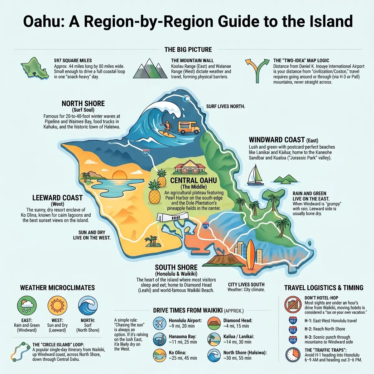
Here is the whole island in one breath, Oahu is small, about 597 square miles, roughly 44 miles long, with one big city on the south shore and five regions wrapped around a mountain spine. Learn those five faces and the map of Oahu stops being a tangle of place names you cannot pronounce and starts being a plan.
The five regions are the South Shore (Honolulu and Waikiki), the Windward Coast (Kailua, Lanikai, Kaneohe), the North Shore (the surf towns up top), the Leeward Coast (Ko Olina and the sunny west), and Central Oahu (Pearl Harbor and the pineapple middle). That is it. That is the map.
Below is the long version, each region's location, vibe, beaches, and best things to do, plus how to get around, how long the drives really take, and how many days you need to see it without living in your rental car.
Table of Contents
- How big is Oahu, and how the map works
- The five regions of Oahu at a glance
- South Shore, Honolulu, Waikiki, and Diamond Head
- Windward Coast, Kailua, Lanikai, and Kaneohe
- North Shore, surf town and shrimp trucks
- Leeward Coast, Ko Olina and the sunny west side
- Central Oahu, Pearl Harbor, pineapple, and the middle
- How to get around Oahu
- Driving times across Oahu
- How many days do you need on Oahu
- Where to base yourself on the map
- FAQ, mapping out your Oahu trip
01
How big is Oahu, and how the map works
Oahu is the third largest Hawaiian island and, somehow, the one everyone assumes is enormous. It is not. At about 44 miles long and 30 miles wide, you can drive a full loop around the populated coastline in a single, snack heavy day.
The trick to reading the map is to stop thinking in north south east west and start thinking in two mountain ranges and the gaps between them. The Waianae Range runs down the west side. The Koolau Range, the green, jagged wall you will photograph 400 times, runs down the east. Between and around them sits everything you came for.
Most of the island's people, hotels, and traffic live on the south shore, where Honolulu spreads out around the airport and Waikiki. From there, the regions fan out, west to the dry resort coast, north over the saddle to the surf towns, and east through a mountain tunnel to the windward beaches.
Two facts make the whole map click into place.
First, almost everyone flies into Daniel K. Inouye International Airport on the south shore, so your distance from the airport is really your distance from "civilization with a Costco." Waikiki is about 20 minutes away. The North Shore is more like an hour.
Second, the Koolau Range is a wall, not a suggestion. Getting from the windward side to town means going through it (via the H-3 or the Pali) or around it. You do not cut straight across the middle, because the middle is vertical.
Hold those two ideas and the rest of this guide is just coloring in the regions.
02
The five regions of Oahu at a glance
Before we go region by region, here is the cheat sheet, the version you would scribble on a napkin for a friend who is leaving Tuesday.
- South Shore (Honolulu and Waikiki): the busy, hotel packed, restaurant everywhere heart of the island. Where most people sleep, eat, and start their trip.
- Windward Coast (East): green, rained on just enough to stay that way, and home to the postcard beaches, Lanikai, Kailua, Waimanalo.
- North Shore: surf town soul, shrimp trucks, giant winter waves, and a gentler summer face. The island's slow side.
- Leeward Coast (West): dry, sunny, less touristy, and home to Ko Olina's calm lagoons and the island's best sunsets.
- Central Oahu: the agricultural plateau in the middle, Pearl Harbor on its south edge, pineapple fields up the spine.
Notice what the map is quietly telling you, rain and green live on the east, sun and dry live on the west, surf lives up north, and the city lives south. That single sentence explains 90 percent of Oahu's weather complaints.
It also explains the classic rookie mistake, booking a "beach day" on the windward side during a passing shower while the leeward side is bone dry 40 minutes away. The island has microclimates. When one side is grumpy, the other side is usually having a lovely time. Chase the sun. It is almost always somewhere on the island.
One more thing the cheat sheet hides, these regions are stitched together by a single coastal road that nearly circles the whole island. You can start in Waikiki, run up the windward coast, loop across the North Shore, drop down the center past the pineapple fields, and be back at your hotel by dinner. The only gap is the far west tip at Kaena Point, where the pavement quits and you have to backtrack. That near complete loop is why a "circle island" day is the single most popular way to meet all five regions at once.
Now, the regions in full.

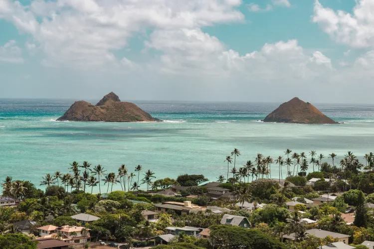
Photo by Cherisse Wong on Unsplash
The whole island at a glance, the five regions, drive times from Waikiki, and which side gets the sun.
03
South Shore: Honolulu, Waikiki, and Diamond Head
The south shore is the part of the map you already picture when you think "Hawaii vacation", high rise hotels, a crescent of soft beach, Diamond Head crater photobombing every sunset shot. This is Honolulu, the state capital, the airport, and Waikiki's two mile hotel strip all stacked along the bottom edge of the island.
It earns the crowds. You can walk to the beach, a hundred restaurants, and a surf lesson before lunch, then watch the sun drop behind the water with a drink you did not have to drive to. If it is your first trip, this is the obvious base, and if you want the full rundown, we wrote a whole guide on where to stay in Oahu.
Diamond Head (Leahi) sits on the east end of Waikiki, an extinct volcanic crater with a paved ish trail to a summit view that is worth every one of the 175 stairs near the top. Reserve a slot in advance. Out of state visitors need a booking, and you can pair it with a guided Diamond Head crater tour if you would rather not fuss with the logistics.
Just east, the coast turns into snorkeling country. Hanauma Bay is a protected reef in a sunken crater, gorgeous, beginner friendly, and reservation only. If you would rather skip the 7 a.m. booking scramble, a Turtle Canyon snorkel trip leaves straight from Waikiki and usually delivers green sea turtles, which is the entire reason anyone snorkels here anyway.
The south shore is also the launch pad for the thing nobody regrets, a sunset on the water. A Waikiki sunset catamaran sail is about as low effort, high reward as Oahu gets. For more ideas in the neighborhood, our roundup of things to do in Waikiki covers the rest.

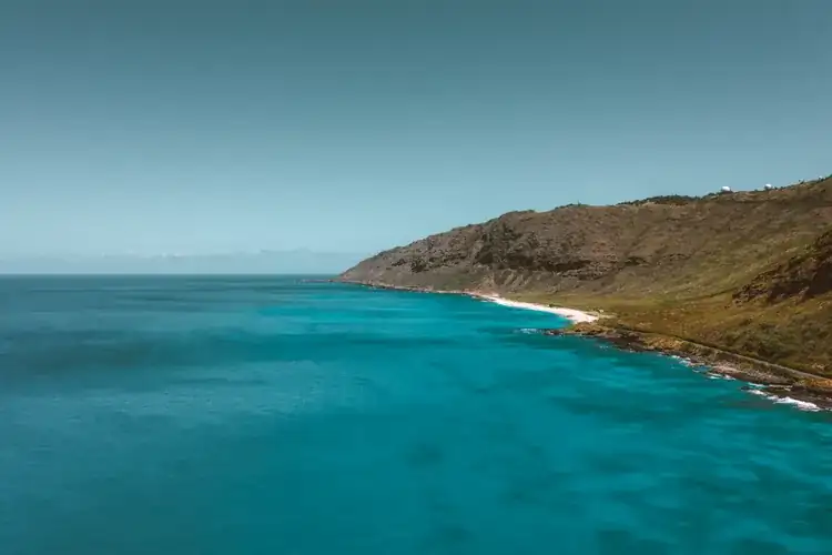
Photo by Josh Smith on Unsplash
04
Windward Coast: Kailua, Lanikai, and Kaneohe
Drive east through the mountains and the island changes personality entirely. The windward coast is the green side, green cliffs, trade wind breezes, and the water that turns up in every Oahu desktop wallpaper.
This is beach country in its purest form. Lanikai is the postage stamp perfect one, powder sand, two little offshore islands, water the color of a swimming pool ad. Kailua Beach next door is bigger, breezier, and better for a full day with the family. We broke both of them down in detail in our Kailua and Lanikai beach guide.
The windward side rains more than the rest of the island, that is the deal you sign for all that green. Showers here tend to be quick and dramatic rather than all day, the kind that soak you for four minutes and then pretend nothing happened. Pack a layer, shrug it off, keep going.
North of Kailua, Kaneohe fronts a wide reef lagoon with a famous sandbar, a patch of knee deep water out in the bay where boat tours drop anchor and everyone stands around in the middle of the ocean like it is a slightly damp cocktail party. It is as fun as it is ridiculous.
Keep heading up the coast and you will hit Kualoa (the "Jurassic Park" valley), the Byodo-In Temple, and a string of quiet roadside beaches. The windward coast is the part of the map where you slow the car down, roll the windows, and accept that you will be stopping every ten minutes. For the rest of the island's sand, our best beaches in Oahu guide has the full list.

Photo by Tom Henderson on Unsplash
05
North Shore: surf town and shrimp trucks
The North Shore is where Oahu takes off its shoes. Up here the map is one long coastal road strung with surf breaks, farm stands, food trucks, and the town of Haleiwa, which has roughly one stoplight and zero interest in hurrying you.
The headline is the surf. In winter, November through February, the breaks at Pipeline, Sunset Beach, and Waimea Bay turn into 20-to-40-foot walls of water and the world's best surfers show up to ride them. You watch from the sand, slack jawed, and you do not get in. In summer those exact same beaches go flat and friendly enough for a float. Same map, completely different ocean, depending on the month. Our full North Shore Oahu guide covers the seasonal swing in detail.
Haleiwa town is the hub, shave ice, surf shops, art galleries, and the famous shrimp trucks out toward Kahuku, where the only correct order is garlic shrimp and a stack of napkins you will absolutely need.
The North Shore is also home to one of the island's best cultural nights. The Toa Luau at Waimea Valley pairs a real imu (underground oven) feast with a botanical garden and a waterfall, we ranked it our top pick in the best luau on Oahu roundup.
If you have never surfed and the flat summer water is calling, a beginner surf lesson up at Haleiwa is the gentlest possible introduction. Just know that the North Shore runs on island time, an hour from Waikiki on a good day, and the day is not always good.
06
Leeward Coast: Ko Olina and the sunny west side
Swing to the west side of the map and the weather flips again, dry, sunny, and reliably warm while the windward side is catching showers. This is the Leeward Coast, quieter, more local, and far less trampled than the south shore.
Its star is Ko Olina, a planned resort enclave with four calm, man made lagoons that are about as kid proof as ocean water gets. This is where Disney's Aulani and the Four Seasons live, and where families who want a stay put, pool and lagoon trip set up camp. You can browse Ko Olina resorts (also on Booking.com) if a resort bubble is the goal.
Those west facing lagoons also make Ko Olina the island's sunset headquarters, the sun drops straight into open ocean here, no mountains in the way. It is the reason this stretch is our favorite for a quiet evening on the sand. (Full disclosure, a sunset beach picnic for two on Oahu starts at $349 through our setups, we may be biased about west facing beaches.)
There is more here than the resort gate, too. Electric Beach (Kahe Point) is a quietly excellent snorkel spot where warm outflow from the power plant draws fish and the occasional turtle. Paradise Cove runs one of the island's long standing oceanfront luaus. And the lagoons themselves are public, there is a shoreline path connecting all four, so you do not have to be a resort guest to walk it at sunset.
Past Ko Olina the road runs out toward Kaena Point, the wild, undeveloped western tip where the pavement eventually quits and a rugged trail takes over. The far Leeward coast (Waianae, Makaha) is rural, real Hawaii, beautiful, with a few beaches like Makaha that are local famous for big winter waves. Visit with respect, park legally, and read the room.
The Leeward side is the part of the map most first timers skip. That is exactly why it is worth a day, figure on about 45 minutes from Waikiki, traffic permitting.
07
Central Oahu: Pearl Harbor, pineapple, and the middle
Central Oahu is the part of the map nobody photographs and everybody drives through. It is the agricultural saddle between the two mountain ranges, red dirt fields, small towns, and the H-2 freeway running up the spine.
But the south edge of this region holds one of the most visited sites in the entire country, Pearl Harbor. The USS Arizona Memorial, the Battleship Missouri, and the aviation museum sit on the water just west of the airport. It is moving, it is free to visit the memorial itself, and the timed tickets go fast, plan it early. Our visiting Pearl Harbor guide walks through the tickets, the timing, and what to skip.
Up the middle from there, the land climbs into pineapple country. The Dole Plantation sits on the route between Honolulu and the North Shore, a famously touristy stop with a hedge maze (once the largest in the world), a little train, and the soft serve everyone pretends they did not drive there for. (You drove there for it.) It is the obvious mid loop break on the way up to Haleiwa, which is exactly why the parking lot is always full.
Central Oahu also gives you the island's best shot at understanding the place beyond the beaches, the plantation history, the small towns like Wahiawa and Mililani, the botanical garden tucked in the hills, and the way the land was farmed long before it was Instagrammed. It is not a "spend three days here" region. It is a "drive through it on the way north and stop twice" region, which, on a map this compact, is exactly how it is designed to work. For the bigger picture, our things to do in Oahu guide ties the regions together.
08
How to get around Oahu
You have three honest options for moving around the map, rent a car, ride TheBus, or let someone else drive.
A rental car is the default, and for good reason, it opens up the whole island, especially the windward and North Shore stretches where transit is thin and the best beaches have no front door. The catch is parking, Waikiki hotels charge a small fortune per night to park a car you will barely use while you are in town. If you are basing in Waikiki and only leaving once or twice, consider renting for just those days.
TheBus is Honolulu's surprisingly excellent public system, and it genuinely circles much of the island for a few dollars a ride. It is slow, but it goes almost everywhere, and for a car free Waikiki trip it is a real option, just not when you are carrying a cooler and three boogie boards.
Letting someone else drive is the move for the big ticket sights. A guided day tour means no parking, no navigating, and no being the designated driver who does not get to nap. The single most efficient way to see the map in one shot is a circle island tour that loops the whole coast for you.
★4.8(4,263)
Oahu Circle Island Tour with Waimea Valley Waterfall
8 hours
Free cancellation
from
$154
A circle island day tour hits the windward coast, the North Shore, and the food stops in one loop, then drops you back at your hotel, ideal for a first day when you want to see the whole island before deciding which corner to go back to. Whatever you choose, build your routes around the airport's south shore location and the fact that the mountains force you to go around, not across.
09
Driving times across Oahu
Distances on Oahu are short. Drive times are a negotiation with traffic, especially the H-1 through Honolulu at rush hour, which moves like a parade nobody enjoys.
Here are rough one way times from Waikiki, on a normal day,
| From Waikiki to | Distance | Drive time |
|---|---|---|
| Honolulu Airport | ~9 mi | 20 min |
| Diamond Head | ~4 mi | 15 min |
| Hanauma Bay | ~10 mi | 25 min |
| Kailua / Lanikai | ~14 mi | 30 min |
| Ko Olina | ~25 mi | 45 min |
| Pearl Harbor | ~11 mi | 25 min |
| Haleiwa (North Shore) | ~30 mi | 55 min |
| Turtle Bay (NE tip) | ~38 mi | 70 min |
The pattern is the thing to remember, nearly everything on the island is within about an hour of Waikiki, and most of it is closer to half that. The longest single drive you are likely to make, Waikiki to the far North Shore, is roughly the time it takes to watch a sitcom episode and its credits.
It helps to know the three freeways, because the names look like a robot's password. H-1 is the main east west artery through Honolulu and the one that clogs at rush hour. H-2 branches north toward Central Oahu and the road to the North Shore. H-3 is the spectacular tunnel route that punches through the Koolau Range to the windward side, arguably the most scenic interstate in the country, which is a sentence I did not expect to write about a freeway.
Two timing traps worth dodging. Morning rush (roughly 6 to 9 a.m.) jams the H-1 heading into Honolulu. Evening rush (3 to 6 p.m.) jams it heading out. And the road to the North Shore funnels everyone home in the late afternoon, so the drive back is always slower than the drive up. Leave early, come back late, and the map shrinks.
10
How many days do you need on Oahu
You can see the headline sights of Oahu in three days. You can enjoy them in five. You can actually relax in seven.
Here is the honest math. Three days gets you the south shore (Waikiki, Diamond Head, a sunset sail), one windward beach day (Kailua and Lanikai), and either Pearl Harbor or the North Shore, not both without rushing. Five days adds the other one, a full North Shore day, and breathing room to do nothing for an afternoon, which is the actual point of Hawaii.
This is the right spot for the one strong opinion I will inflict on you, do not hotel hop around the island. People see a map with five regions and assume they need to sleep in three of them. You do not. Oahu is 44 miles long. From a single base in Waikiki, you can reach nearly every spot on this entire guide in under an hour, so packing, checking out, and re checking in just to save 25 minutes of morning driving is a tax on your own vacation. Once you have picked the base, our best activities in Oahu guide sorts what to actually do, by type and price. Pick one base and let the rental car do the commuting.
The exception is a deliberate split, a few nights in busy Waikiki, then a few in the slow North Shore or sunny Ko Olina, specifically because they feel like different trips. That is a feature, not a logistics fix. Our where to stay in Oahu guide breaks down which base fits which kind of traveler.
And if you have a full week, the move is not to cram in more sights, it is to repeat the ones you loved. A second slow morning at Lanikai. A second sunset sail. A return trip to the shrimp truck you have been thinking about since Tuesday. Oahu rewards going deep on a few places far more than it rewards speed running all five regions with a checklist and a clenched jaw.
11
Where to base yourself on the map
Match the region to the version of yourself on this trip.
- First timers and the cannot decide crowd: Waikiki, south shore. Most hotels, easiest logistics, beach out front, half the island reachable without a car.
- Families who want to stay put: Ko Olina, Leeward. Calm lagoons, resort pools, sunsets into open water.
- Beach town romantics: Kailua, windward. Real Hawaiian town, the best sand on the island, a 30-minute hop from Honolulu.
- Slow down seekers and surf watchers: the North Shore. Quiet, scenic, far from the noise in the best way.
- Budget minded and walkable first: Ala Moana, just west of Waikiki, cheaper, near the biggest mall and a calm beach park.
A quick gut check before you book, open the map, drop a pin on the three things you are most excited about, and notice where they cluster. If two of the three are in town, sleep in town. If they are scattered across the windward and North Shore, a Waikiki base plus a long loop day beats moving hotels. The geography does the deciding for you once you stop arguing with it.
The mistake is not picking the "wrong" region, there is not one. The mistake is picking a base that fights your itinerary, a North Shore villa when half your plans are in town, or a Waikiki high rise when all you wanted was quiet. Read the map for what you actually want to do, then sleep nearby. To stitch a few regions into a day by day plan, our things to do in Oahu and North Shore guides are the next stops.
FAQ: mapping out your Oahu trip
How big is Oahu, really?
About 597 square miles, roughly 44 miles long and 30 miles wide. It is the third largest Hawaiian island, but compact enough that you can drive the full coastal loop in a single day. Almost every major sight sits within an hour of Waikiki.
What are the regions of Oahu?
Five, the South Shore (Honolulu and Waikiki), the Windward Coast (Kailua, Lanikai, Kaneohe), the North Shore (the surf towns), the Leeward Coast (Ko Olina and the west side), and Central Oahu (Pearl Harbor and the pineapple plateau). Rain and green live on the east, sun and dry on the west, surf up north, and the city on the south.
Which side of Oahu is best to stay on?
The south shore (Waikiki) for first timers and convenience. The Leeward side (Ko Olina) for families and resorts. The windward side (Kailua) for beach town quiet. The North Shore to slow all the way down. There is no wrong answer, just match the base to your trip. The official Hawaii tourism guide to Oahu is a good second opinion.
Do you need a car to get around Oahu?
For Waikiki and the south shore, no, you can walk, bus, and take tours. For the windward coast, North Shore, and far west, a car makes life much easier, since transit there is thin and the best beaches are spread out. Many visitors rent a car only for the days they leave town.
How many days should you spend on Oahu?
Three days for the highlights, five to enjoy them without rushing, seven to actually relax. Three days covers the south shore plus one of either Pearl Harbor or the North Shore. Five lets you do both with room to breathe.
What is the wettest part of Oahu?
The windward (east) side and the Koolau mountains catch the most rain, which is exactly why they are so green. Showers there are usually quick. The Leeward (west) side, including Ko Olina, is the driest and sunniest, so if one side is gray, the other is often clear.
Where is the best snorkeling on the map?
The south east corner, Hanauma Bay is the famous protected reef (reservation required), and boat trips out of Waikiki reach Turtle Canyon for reliable green sea turtles. For the full breakdown, see our best snorkeling on Oahu guide.
Pick your five faces, pick one bed, and let the rental car earn its keep. The map of Oahu is not big, it just looks that way until someone draws the clock for you. Now go stand in the middle of a bay at a sandbar cocktail party and tell me it was not worth the drive.
Disclosure: Some links on this page are affiliate links. If you book or buy through them we may earn a small commission, at no extra cost to you. As an Amazon Associate, we earn from qualifying purchases.