Kahekili Highway Maui: The Honest 2026 Drive Guide
16 min readYndira W. Tonin
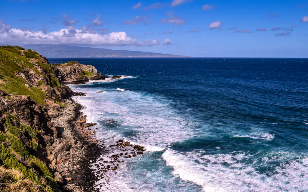
The Kahekili Highway Maui locals call Route 340 is the narrow, one lane back road around the wild north end of West Maui - about 21.5 miles of cliff hugging pavement that runs from Kapalua, around the island's remote top, down to Wailuku. It's free, it takes two to three hours with stops, and it's the road your rental contract politely pretends doesn't exist.
That last part isn't a dare. It's a real drive with real consequences - blind curves, no guardrails, and stretches where the pavement shrinks and two cars must sort out who reverses. Done right, it's the most spectacular, least crowded scenery on Maui; done carelessly, it's how a vacation ends early.
This is the honest guide to driving the Kahekili Highway - whether it's safe, which way to go, the best stops in order, how it compares to the Road to Hana, and when to skip it - all current as of 2026. It's for confident drivers who want the empty, wild side of the island, not white knuckle passengers on a tight schedule. (We run beach picnics on Oahu, not Maui, so there's nothing to sell you here - just the road notes.)
Cover photo: Engin Yapici on Unsplash.
Table of Contents
- Is the Kahekili Highway safe to drive?
- Getting to the Kahekili Highway: route, direction, and driving time
- Driving the Kahekili Highway: the best stops, in order
- Kahekili Highway vs the Road to Hana
- When to drive the Kahekili Highway, and what to pack
- Make a West Maui day of it
- FAQ: Kahekili Highway Maui
01
Is the Kahekili Highway safe to drive?
Yes, for a careful driver in daylight - but it earns its reputation as one of the most dangerous roads in Hawaii. The Kahekili Highway is paved the whole way, which surprises people, but pavement is where the reassurance ends. The middle section is a narrow cliff road that pinches to a single lane with no guardrail between you and a long drop to the Pacific Ocean - the curves are blind, the hairpin turns are tight, and the one lane bridges expect you to already know who yields to oncoming traffic.
The genuinely tense part is the roughly 13-mile stretch through the middle, where the road switches from state to county maintenance and any pretense of a shoulder disappears. It's barely wide enough for two cars in places, signs warn of falling rocks, and speed limits drop to 15 mph or slower - which isn't bureaucratic caution, it's the speed at which you can actually stop for a stray dog, a local pickup, or a switchback you didn't see coming.
The wild back road around West Maui
Here's the part the brochures skip: most major rental car agreements on Maui prohibit driving past the "State Highway Ends" sign north of Kapalua. The road is paved, so the usual unpaved road clause is murky, but the agencies simply don't want to send a tow truck 40 minutes into the middle of nowhere to recover one stuck car. Most companies won't recommend it, and some won't cover damage to the vehicle if you ignore the sign. Read your own contract before you commit - if something goes wrong out here, you may be covering the bill yourself. (The state lists Route 340 among its Maui state roads, for what the official designation is worth.)
The rental car rules, plainly
Most agencies say noRule
contracts prohibit driving past the 'State Highway Ends' sign north of Kapalua.
It is pavedWhy
so the usual unpaved-road clause is murky - the real reason is how far help is.
You may not be coveredRisk
damage or a tow from out here could land on you, not the insurer.
Read your own contractDo
the wording varies by company; check yours before you commit.
None of that should scare off a confident driver. Plenty of people drive it every year without incident, and most come back calling it the best experience of their trip. It just means you treat it as a slow, deliberate adventure - not a shortcut, not a place to multitask, and not a road you take if curves make your passenger reach for the door handle.
02
Getting to the Kahekili Highway: route, direction, and driving time
The Kahekili Highway is the northern half of the loop around the West Maui mountain range, located on the far, wild side from the resorts. Most people pick it up from the west: head north past Kapalua on the Honoapiilani (Honoapiʻilani) Highway, and a few miles past the last resort the road runs out of civilization and becomes Route 340, tracing the coastline all the way around to Kahului and Wailuku.
Drive it from west to east - Kapalua toward Wailuku - and you'll spend the scary parts in the inland lane instead of out on the cliff edge. It also follows the direction most traffic moves, so you're less likely to meet someone head on where neither of you can pass. The reverse works, but it puts you on the ocean side of a one lane road when a truck rounds the bend.
When you meet another vehicle on a single lane, the rule is simple: the car going uphill keeps moving; the one heading down reverses to a pullout for passing. Travel slowly, give way to the work trucks and larger vehicles out here, and remember help is far away.
Driving to the Kahekili Highway
Tap to open Google Maps with turn-by-turn directions.
Four rules for the Kahekili Highway
Rent something smallVehicle
a compact, not a big SUV or van - the road pinches to about a lane and a half.
Drive west to eastDirection
Kapalua toward Wailuku keeps you in the inland lane, not on the cliff edge.
Uphill has the right of wayEtiquette
the car climbing keeps moving; the one heading down backs up to a turnout.
Go slow, tap the hornPace
about 15 mph, a light horn before blind curves, and pull over to let locals by.
Budget two to three hours one way with stops - not for the distance, it's only about 21.5 miles, but because you'll average 15 to 20 mph and pull over constantly. One quirk to know: the mile markers reset. Coming from Kapalua they count up to about 38 on the Honoapiilani side, then the highway changes designation near the top and the 340 markers count back down from around 16 toward Wailuku. Don't let it rattle you - just follow the stops in order.
Fuel up first. There's no gas, no store, and no charging the entire way, and cell service drops out for long stretches. Download an offline map, top off the tank, and tell someone when to expect you out the other side.
The move: Kapalua to Wailuku, west to east · Time: 2-3 hours with stops · Distance: ~21.5 miles · Fuel and service: none, so top off first.
03
Driving the Kahekili Highway: the best stops, in order
The stops are the reason to do this instead of admiring the West Maui Mountains from a beach chair. Taken from the Kapalua side, here's the run of them along the way - a blowhole, a clifftop trail, lava pools, a village that time forgot, and a sea cliff with a legend attached.
Driving the Kahekili Highway from Kapalua
- 1Hwy 30, MM ~38
Nakalele Blowhole
a sea vent that fires seawater up to ~100 feet; stay well back, people have died on these rocks
- 2Hwy 30, MM ~41
Ohai Loop Trail
an easy 1.2-mile clifftop loop with some of the coast's best free views
- 3Hwy 340, MM ~16
Olivine Pools
tide pools below a lava shelf - a steep scramble, calm days only (full guide linked below)
- 4Hwy 340, MM ~14
Kahakuloa Village
30-some residents, a little green church, and two banana-bread stands worth the cash
- 5Hwy 340, MM ~13
Kahakuloa Head
the 636-foot sea cliff where chief Kahekili was said to leap 200 feet before breakfast
- 6Hwy 340, MM ~7
Waihee Ridge Trail
the marquee West Maui hike near the Wailuku end (full guide linked below)
Honolua Bay and Dragon's Teeth (the warm up)
Before the road even narrows, the west end strings together a couple of worthwhile stops. Honolua Bay is a marine life reserve and one of Maui's best snorkel and surf spots, with a short forest walk to the water, and the Dragon's Teeth lava formation at Makaluapuna Point sits just south near Kapalua. Both are easy roadside stops on the Honoapiilani Highway before the lookout where the pavement narrows - the gateway to Maui's wild north shore, located past the last resort.
Nakalele Blowhole
Near mile marker 38 on the Honoapiilani side, the Nakalele Blowhole is the loudest headliner along this coast - a natural vent in the lava shelf that fires a column of seawater up to about 100 feet when the surf forces water through the hole. It's a 10-to-15-minute walk down over open rock from the pullout, with no shade and no railing.
It's also genuinely dangerous. People have died here over the years, swept off the rocks by rogue waves, and the county has posted warning signs for that reason. Stay well back from the hole and the wet rock around it - the close up photo is never worth it. Our full Nakalele Blowhole guide covers the parking, the walk, and when it fires biggest.
Cost: free · Walk: 10-15 min over open rock · Watch for: rogue waves - keep off the wet rock.
Ohai Loop Trail
A couple of miles further, around mile marker 41, the Ohai (ʻOhai) Loop Trail is the easiest worthwhile stop on the whole drive - a 1.2-mile clifftop loop through low coastal shrub with wide open views of the sea cliffs and, on a clear day, Molokai across the channel. It's flat, exposed, and takes 30 to 45 minutes. It's a free state Na Ala Hele trail with a small parking lot off the highway - a good leg stretch before the road narrows, with no shade, so go in the morning. For the island's other marquee walks, our best hikes in Maui guide rounds them up.
Cost: free · Distance: 1.2-mile loop · Time: 30-45 min · Best for: an easy view stop.
The Olivine Pools
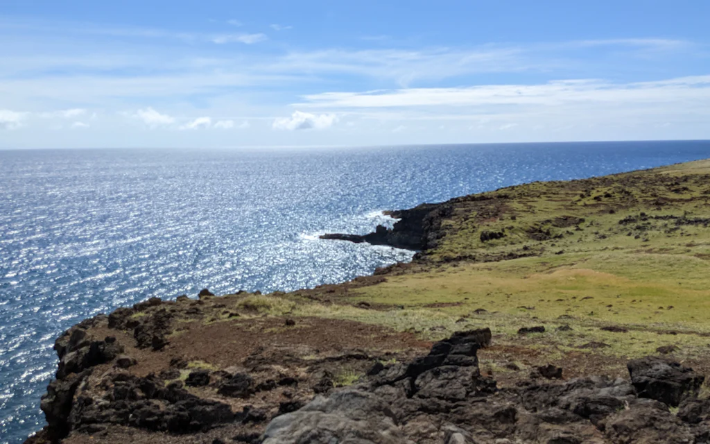
Once the road becomes Route 340, around mile marker 16, you reach the Olivine Pools - tide pools sitting in the lava bench below the highway, named for the green olivine crystals in the rock. From the small pullout it's a steep, rough scramble down the lava, and they're only safe to approach, let alone swim, on a flat, calm, low tide day.
Most days the smart move is to enjoy the pools and the wave battered coast from the cliff above - a genuinely great view in its own right. If conditions and your shoes are right, it's one of the most dramatic free swims on Maui. For the full rundown on the scramble, the swim window, and how to read the ocean here, see our complete guide to the Olivine Pools.
Cost: free · Access: steep lava scramble · Swim: calm, low tide days only.
Kahakuloa Village and the banana bread
Around mile marker 14, the road drops into Kahakuloa Village - maybe 30 residents, a tidy green church, taro patches, and the most isolated inhabited area on Maui's road network. It's one of the few spots out here that sees tourists at all, but it's a real place first, not an attraction, so drive slowly, don't block driveways, and treat it like someone's front yard, because it is.
The reason most people visit is the banana bread. Julia's Best Banana Bread sells warm loaves from a green stand right on the highway, and Lorraine's does a banana bread and coconut candy a little further along. You will be told it's the best banana bread on Maui. You will, annoyingly, agree. Bring small bills - it's cash only, and there's no ATM for 20 miles.
The stop: banana bread + a photo of the village · Bring: cash, small bills · Mind: it's a living village, not a set.
Kahakuloa Head and Kahekili's Leap
Just past the village, the 636-foot sea cliff called Kahakuloa Head (Puʻu Koaʻe) rises straight out of the ocean - the single most photographed landmark on the drive. This is also Kahekili's Leap, named for the 18th-century Maui chief Kahekili, the road's namesake, who was said to leap the 200 feet from the cliff into the sea before breakfast in the ancient sport of lele kawa - feet first, no splash.
He was a rival of Kamehameha and a famous warrior, and whether or not the leap is literal, the cliff is real and the legend makes merely driving past it feel pretty reasonable. There's a pullout for photos; the route up the head is steep and discouraged, so admire it from the road.
See it from: the roadside pullout · The story: chief Kahekili's morning leap · Don't: climb the head - it's unsafe.
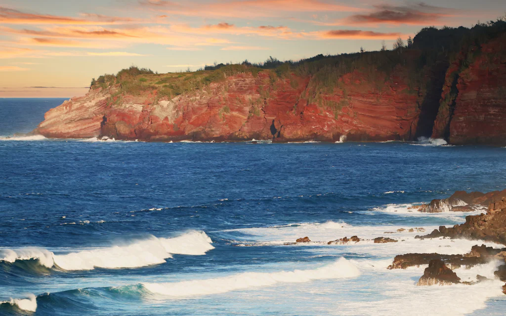
Photo: Simon Hurry on Unsplash.
Waihee Ridge Trail
As the highway descends toward Wailuku, around mile marker 7, a side road climbs to the Waihee (Waiheʻe) Ridge Trail - the best big view hike in the West Maui Mountains, about 4.5 miles round trip up a green ridge to the Lanilili summit. It's a real workout and a worthy cap to the drive if you've got the legs for it.
If you'd rather just finish the drive, fine - but it's the stop that turns a scenic drive into a full day. See our honest Waihee Ridge Trail guide for the parking reality and section by section climb.
Cost: free · Distance: ~4.5 miles round trip · Time: 2.5-3 hours · Best for: confident hikers.
04
Kahekili Highway vs the Road to Hana
Everyone compares these two famous drives in Hawaii, so here's the honest version. The Road to Hana is the famous one, and the Kahekili Highway is the better one if you hate crowds - they sell completely different days.
The Road to Hana is a 64-mile, full day pilgrimage past waterfalls, rainforest, and a black sand beach, on a paved two lane road with some 600 curves and more than 50 one lane bridges. It's legendary for good reason, and it's busy - you'll be in a slow convoy of rental cars most of the way. The Kahekili Highway is shorter, wilder, emptier, and rougher: half the distance, a fraction of the traffic, and stops you'll have largely to yourself.
The two even point your eyes differently: the Road to Hana looks inland at waterfalls and rainforest, while the Kahekili Highway hugs the open ocean - the West Maui Mountains on one side, raw cliffs dropping to the Pacific on the other, and almost no one around to share the views.
Kahekili Highway vs the Road to Hana
Kahekili Highway
Route 340 - the wild side
- ~21.5 miles, 2-3 hours one way
- Narrow, one-lane and guardrail-free in the middle
- Nearly empty - you may pass almost no one
- Free stops: a blowhole, lava pools, a village
- Most rental contracts technically prohibit it
Road to HanaOur pick
Route 360 - the famous one
- ~64 miles, a full day round trip
- Paved, two lanes, ~600 curves and 50+ one-lane bridges
- Busy - convoys of rental cars
- Waterfalls, rainforest, black-sand beach
- Rental-legal the whole way
My honest take, and the one opinion I'll plant a flag on: if you've already done the Road to Hana and want the opposite of crowds, the Kahekili Highway is the better half day. You'll pass more cars in the first mile of the Road to Hana than on the entire Kahekili Highway. Just know the trade - the Road to Hana is rental legal and forgiving; the Kahekili Highway is neither. If it's your only drive and you've got kids, a big rental, or a nervous co pilot, do Hana. If you want Maui with the volume turned down, come up here.
05
When to drive the Kahekili Highway, and what to pack
Timing is mostly about weather and daylight. Drive it on a dry, clear morning - early light is kind on the cliffs, the pavement is dry, and you beat what little traffic there is. The afternoon brings haze, the occasional tour van, and a lower, harsher sun. Check the forecast the night before; West Maui weather turns fast.
When to drive it, and when to skip
Go: a dry morningBest
early light, dry pavement, and you beat what little traffic there is.
Go: a clear forecastGood
blue sky means you actually see the coast instead of a wall of cloud.
Skip: after heavy rainNo
rockfall and washouts close this road; it is not worth the gamble.
Skip: at night or nervousNo
no lights, no shoulder, no margin - a daylight-only, confident-driver road.
And the honest part - when to skip it entirely. Don't drive it after heavy rain: this road closes for rockfall and washouts, and a slick one lane curve over a long drop is not where you want to learn your tires are bald. Don't drive it at night - no lights, no shoulders, and no margin for error make a tricky road genuinely dangerous in the dark. Don't drive it in a big SUV or a rental van, because the pinch points were not built for you. And don't drive it if curves genuinely frighten you or your passenger; there's no shame in it, and a terrified white knuckle hour is no one's idea of a vacation. The road will still be here next trip.
As for what to bring, you're heading into a 21-mile dead zone with no services, so pack like it.
What to bring on the Kahekili Highway
A full tankFuel
no gas, no stores, no charging for 21.5 miles - fuel up in Kapalua or Wailuku first.
Offline mapsNav
cell service quits for long stretches; download the route before you lose signal.
Small billsMoney
cash for the banana-bread stands and roadside fruit - no card readers out here.
Motion-sickness helpStomach
the curves are relentless; take it before you start, not after you turn green.
Start with a full tank and a downloaded map - the two non-negotiables. After that it's comfort and the stops: water and snacks, a hat and reef safe sunscreen for the shadeless trails, and closed toe shoes with grip if you plan to scramble to the Olivine Pools or out to the blowhole; the lava is sharp and the rock gets slick.
The most underrated item is motion sickness relief, taken before you start. This road is nothing but curves, and the place to deal with a queasy passenger is not a one lane cliff with nowhere to pull over. Toss in cash for the banana bread and a light jacket - the inland stretch near Waihee can be cool and misty even when the coast is baking.
06
Make a West Maui day of it
The Kahekili Highway bookends naturally with the resort coast to the south. Most people base in West Maui - Kapalua, Kaanapali, or Lahaina - drive up in the morning while it's cool and quiet, and come back down to an easy afternoon on calm sand. After a morning of cliffs and curves, that flat, friendly ocean is exactly the counterweight you want: an easy reef snorkel at Black Rock Beach in Kaanapali, or a west facing stretch of sand for the Maui sunset.
For the bigger picture, our things to do in Maui guide and the best beaches in Maui roundup put the back road in context with the rest of the island. If you're choosing a base, where to stay in Maui compares the West Maui towns closest to this coast, with Kapalua near the western end of the drive and Wailuku at the eastern one.
Drive the full loop back south and the lush Iao Valley and old town of Wailuku sit at the eastern end of Route 340 - an easy valley walk before you head back to the resort coast.
If the drive sounds like more adventure than you signed up for, the guided Road to Hana circle tour below lets someone else handle Maui's other white knuckle road - and the West Maui snorkel and sunset sails are the perfect calm reward after a morning of curves.
Read this next: the complete Olivine Pools guide - the wildest stop on the whole drive, in full detail.
FAQ: Kahekili Highway Maui
Can you do the Kahekili Highway and the Road to Hana on the same day?
Realistically, no. They're on opposite ends of the island and each is at least a half day - the Road to Hana is a full one. Pick one per day: the Road to Hana for waterfalls and rainforest, the Kahekili Highway for empty coast and a quiet village.
Are there bathrooms or food on the Kahekili Highway?
Essentially none. Kahakuloa's banana bread and fruit stands are the only food, and there are no public restrooms, gas stations, or stores along the whole route. Use the bathroom and fuel up in Kapalua or Wailuku before you leave, and carry your own water and snacks.
Is the Kahekili Highway scarier than the Road to Hana?
Yes - it's narrower, has no guardrails, and far less traffic to follow. The Road to Hana is busier but more forgiving: two lanes, clear signage, and a steady stream of cars. The Kahekili Highway's middle section is genuinely one lane in spots, so it feels more remote and exposed.
When is the Kahekili Highway closed?
After heavy rain, mainly - for rockfall and washouts - plus the occasional maintenance closure. The road is open most days, but in the wet winter months check conditions before you go: a fresh storm can shut the narrow middle stretch with little warning.
Is the Kahekili Highway worth it?
For a confident driver who wants empty, dramatic scenery, absolutely. It's one of the most remote, least crowded drives in Hawaii, with free stops you'll often have to yourself. For a nervous driver, a tight schedule, or a big rental vehicle, it's not - the Road to Hana delivers a more forgiving version of the scenic drive day.
Disclosure: Some links on this page are affiliate links. If you book or buy through them we may earn a small commission, at no extra cost to you. As an Amazon Associate, we earn from qualifying purchases.


