Nakalele Blowhole Maui: The Honest 2026 Guide
11 min readYndira W. Tonin
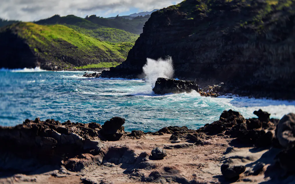
The Nakalele Blowhole Maui visitors line up for is a sea vent on the island's wild north coast that fires seawater 50 to 100 feet into the air - a hole in the lava bench that does exactly one thing, spectacularly, every few minutes. It's a free to see roadside stop near mile marker 38.5, about 45 minutes north of Lahaina (Lāhainā), reached by a short, rough walk over open rock.
It's also one of the most genuinely dangerous "attractions" on Maui - people have died here, swept off the rocks or pulled into the hole - so the trick is seeing it at full force without becoming part of the show.
This is the honest guide to the Nakalele Blowhole - what it is, how to get there, where to park (it's paid now), when it performs, and the safety rules that actually matter - all current as of 2026. It's for anyone road tripping the north coast who wants the spectacle without the obituary. (We run beach picnics over on Oahu, not Maui, so there's nothing to sell you here - just the notes.)
Cover photo: Cate Bligh on Unsplash.
Table of Contents
- What is the Nakalele Blowhole?
- How to get to the Nakalele Blowhole
- Is the Nakalele Blowhole safe?
- When to see the Nakalele Blowhole at its best
- More to see at Nakalele Point
- FAQ: Nakalele Blowhole Maui
01
What is the Nakalele Blowhole?
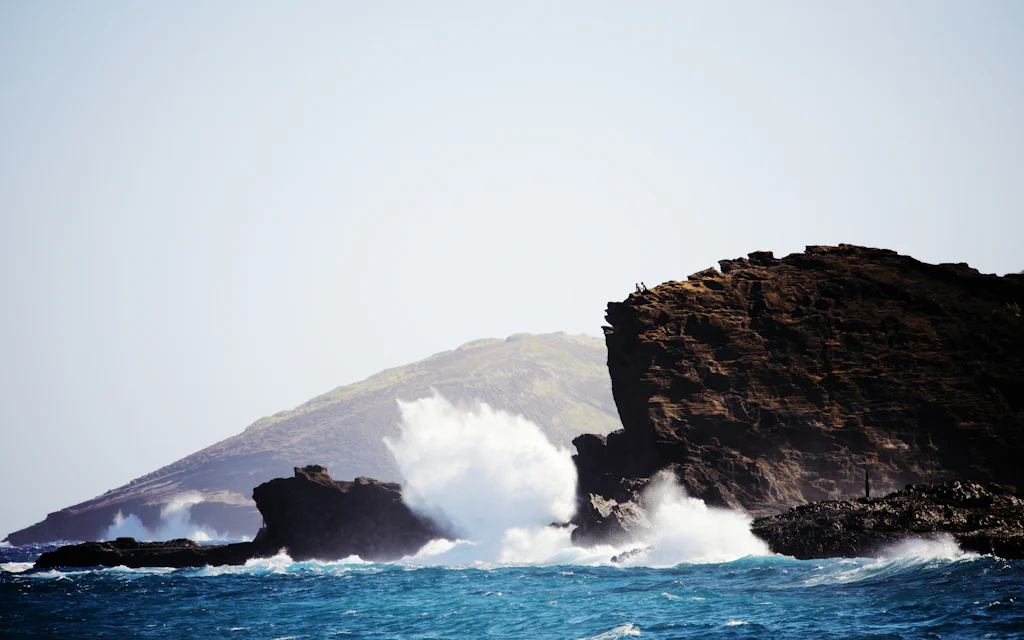
The Nakalele Blowhole is a natural geyser on Maui's north coast, where the sea has carved a roughly 3-foot hole in a flat shelf of lava right at the water's edge. When a wave surges in, it forces seawater and trapped air up through the hole under pressure, and the whole thing erupts in a column that can reach 50 feet on an ordinary day and closer to 100 on a big swell.
Maui's exploding north-coast sea vent
It keeps no schedule and takes requests from no one - you wait for the ocean. On a decent swell it fires every minute or two; in flat summer surf it can sputter or barely go at all. You'll often feel the ground thump a beat before the spray goes up, which is the cue to have your camera ready and your feet planted somewhere safe. When a large set rolls through, the next spout can be the one that soaks anyone who crept too close - and half the entertainment is watching that happen to someone else.
Why the water fires 50 feet up
- 1The setup
A hole in the lava bench
the sea has carved a roughly 3-foot vent in the rock shelf right at the water's edge
- 2The surge
A wave funnels in
incoming swell forces seawater and trapped air up through the hole under pressure
- 3The spout
It erupts 50-100 feet
a geyser-like jet goes off every few minutes - bigger on a strong north or west swell
- 4The catch
Biggest spout, worst footing
the same swell that makes the best show floods the very rocks you'd stand on
The blowhole sits at Nakalele Point, the blunt northern tip of West Maui, on the same wild stretch of coast as the Olivine Pools a few miles further along. It's one of the more reliable natural spectacles in this part of Hawaii, and the headline stop on the back half of the Kahekili Highway drive. For most people it's a 20-to-40-minute pull off rather than a destination in itself, so plan it as one stop among several on a West Maui north coast day, not the whole trip. The views up and down this rugged coastline are worth the pull off even between eruptions.
02
How to get to the Nakalele Blowhole
The Nakalele Blowhole is near mile marker 38.5 on the Honoapiilani (Honoapiʻilani) Highway, about 8 miles north of Kapalua on the road that becomes the Kahekili Highway. From Kaanapali (Kāʻanapali) it's roughly a 30-minute, 15-mile drive; from Lahaina about 45 minutes; from Wailea closer to an hour and 15.
Driving to the Nakalele Blowhole
Tap to open Google Maps with turn-by-turn directions.
It's located out on West Maui's north shore, and the travel time from the resorts is short - typing "Nakalele Blowhole" into Google Maps gives accurate directions straight to the main lot. There are two pull offs. The mile marker 38.5 lot is the one you want - it's the main lot, closest to the blowhole, with the best view down and the shortest walk. The mile marker 38 lot starts a longer hike past the Nakalele Point light beacon and tide pools, a 1.25-mile round trip. Both trails are unmarked and braid across open rock, so keep the lot in sight on the way down and a downloaded map handy - cell signal drops out up here. Heads up on the road, too: the highway narrows toward one lane in spots, so take it slow.
One change worth knowing: the lots that were free for years now charge a paid parking fee, reserved ahead online through a QR code - rates have been a moving target, so check the current one before you go. From the 38.5 lot it's about a 0.6-mile round trip down to the blowhole - 15 to 25 minutes of hiking each way over rocky, uneven lava with no railing and no shade. Wear real shoes; the lava has eaten better flip flops than yours. It's a scramble, not a stroll, and most travelers find the way down easy enough and the climb back the part that earns the banana bread. The footing is the first half of why this stop demands respect.
Parking: mile marker 38.5, paid + reservable · Walk: ~0.6 mi round trip, 15-25 min each way · Bring: real shoes, water · Drive: ~30 min from Kaanapali, ~45 from Lahaina
03
Is the Nakalele Blowhole safe?
Seeing the Nakalele Blowhole is safe; getting close to it is not. This is the part the postcard photos skip: people have died here, swept off the lava shelf by rogue waves or sucked into the hole itself, and Maui County has posted warning signs - one at the parking lot, another right before the trail - asking for extreme caution. They aren't decoration; the ocean here gives no second chances. If any swell is running, check the Maui ocean safety forecast before you go.
Staying alive at the Nakalele Blowhole
Stay well backRule
the deadly zone is the wet rock around the hole - keep a wide margin, always.
Never turn your backRule
rogue waves wash the shelf without warning; face the ocean the whole time.
Heed the signsHeed
the county posts warnings at the lot and the trail because people have died here.
Skip it in big surfWhen not
huge swell means a huge spout and a flooded, lethal approach - watch from up high.
The danger is the wet rock around the vent, where the spray and surge make the footing treacherous and a bigger than expected set can wash the shelf - and you - clean away without warning. Stay well back, and never turn your back on the ocean to line up a photo. The rule that keeps you alive is boring and absolute: pick a spot on the dry, high rock, watch a few eruptions to read how far the water reaches, and then stay well further back than that. Kids and dogs should be hands on the whole time, not roaming the lava. Don't try to time a photo by going closer between sets - that is exactly how the people memorialized on the warning signs got into trouble, and how others before them did. The blowhole has outlasted everyone; treat it like the local force of nature it is.
The blowhole is most lethal in exactly the conditions that make it most impressive - a big north or west swell. If the surf is really up, the smart move is to enjoy the show from the higher ground near the lot rather than picking your way down to the shelf. The spectacle is the same from up there; the risk is not.
04
When to see the Nakalele Blowhole at its best
Time your visit for a rising or high tide - more water in the hole means a bigger, more reliable spout. A little north or west swell adds power; dead flat summer days can leave it barely puffing. The honest opinion, and the one I'll stand on: aim for some swell but not a storm, because the same waves that double the spout also flood the rocks you'd watch from, and a 100-foot geyser is not worth a body recovery story.
When the Nakalele Blowhole performs
A rising or high tideBest
more water in the hole means a bigger, more reliable spout.
MorningGood
softer light, fewer people, and you beat the midday heat on the shadeless rock.
Some swell, not a stormGood
a little north or west swell powers the jet; a big one floods the danger zone.
Not after heavy rainNo
the lava turns slick and the one-lane road up gets dicey.
Visiting in winter (roughly November through March) brings the biggest north swells and the most dramatic spouts in Hawaii - along with the highest stakes, so pick your day and your distance carefully. Mornings are the sweet spot year round: softer light, fewer people, and you beat the worst of the heat on that shadeless rock. Don't show up before about 10 if you were counting on the banana bread, because MamaLei's roadside stand up the hill doesn't open until then. And skip the area entirely right after heavy rain, when the lava turns slick and the one lane road up gets genuinely sketchy.
A few practical notes the older guides skip: the parking fills by midmorning in peak season, so download the route before you lose signal and arrive early. Many West Maui road trips bundle the blowhole with the Olivine Pools, so budget the travel time between them, and the Nakalele Point lighthouse beacon and tide pools make a worthwhile add-on if you've got an extra half hour.
If you only do one thing here, watch the ocean before you watch the hole. Spend two minutes reading the sets from up high, and the entire visit gets both better and safer.
05
More to see at Nakalele Point
The blowhole is the headliner, but Nakalele Point has a small supporting cast worth the extra few minutes. The strangest is the "Acid War Zone," a field of pitted, eroded rock formations near the point that look like the surface of another planet - wind, salt, and time doing slow, weird work on the lava.
What else is at Nakalele Point
The Acid War ZoneSee
a field of weirdly pitted, eroded rock formations near the point - genuinely strange.
Nakalele Point LightSee
a small light beacon and tide pools out past the mile-marker 38 lot.
Heart Rock is goneNote
the famous heart-shaped hole collapsed into the sea in late 2019 - don't go hunting for it.
MamaLei's banana breadEat
the roadside stand up the hill; it doesn't open until after 10 am.
Out past the mile marker 38 lot, a short hike reaches the Nakalele Point light beacon and a set of tide pools, a quieter payoff if the blowhole crowd gets old. If you're the type who turns a photo stop into a half day of hikes and side adventures, the open ground around the point rewards it - just watch your footing, because the same loose lava is everywhere. One thing not to go hunting for: the famous heart shaped hole in the rock that filled half the internet's Maui photos. The sea took Heart Rock back in late 2019 - the most on brand thing this coast has ever done - so any guide still featuring it is out of date.
Most people fold Nakalele into a bigger north coast day. It pairs naturally with the Olivine Pools and the full Kahekili Highway loop - or a guided van tour of the area if you'd rather not drive the narrow road yourself - and the calmer beaches and snorkeling down in West Maui make the easy counterweight afterward. If you're still mapping the trip, our things to do in Maui guide and where to stay in Maui put this corner in context with the rest of the island.
Read this next: the complete Olivine Pools guide - the wild green tide pools a few miles up the same coast.
FAQ: Nakalele Blowhole Maui
What happened to the heart shaped rock at the Nakalele Blowhole?
It collapsed into the sea in late 2019. The heart shaped hole in the lava - often called Heart Rock - was one of Maui's most photographed spots until the surf that carved it finally broke it apart. Any guide still sending you to find it is out of date; the blowhole and the coast are very much still there.
How often does the Nakalele Blowhole erupt?
Every minute or two on a decent swell, and barely at all when the ocean is flat. It runs entirely on the surf, so there's no schedule. A rising tide with some north or west swell gives the most frequent, most powerful spouts; a calm summer day can leave it sputtering.
How was the Nakalele Blowhole formed?
By the sea slowly boring a hole through a shelf of lava. Wave action and erosion opened a vent in the hard volcanic bench at the water's edge, and now incoming swell compresses water and air through that narrow gap and blasts it skyward - the same process that built the surrounding "Acid War Zone" formations.
How long do you need at the Nakalele Blowhole?
About 30 to 60 minutes, including the walk. Figure 15 to 25 minutes each way over the rocky lava, plus time to watch a few eruptions from a safe distance. Add more if you're exploring the light beacon and tide pools at the mile marker 38 end.
Is the Nakalele Blowhole worth it?
Yes, if you treat it as a quick, careful roadside stop rather than a swim spot. It's a genuinely dramatic, free natural spectacle and a memorable experience on a wild coast, and we'd recommend it to any traveler driving this shore. It's not worth it if the surf is huge and you'd be tempted to get close, or if you can't manage a rocky scramble - in that case, enjoy it from the lot up top.


