Waihee Ridge Trail Maui: The Honest 2026 Hiking Guide
14 min readYndira W. Tonin
The Waihee Ridge Trail Maui hikers love is about 4.5 miles round trip with roughly 1,500 feet of climbing - a steep out and back up the spine of the West Maui Mountains to the Lanilili summit at 2,563 feet. It's short on distance and long on payoff - the best big view ridge hike on the island - but the whole thing hinges on one boring detail: getting to the parking lot early enough to park.
Get that right and you climb through cloud forest to a summit with the green interior of Maui on one side and the ocean on the other. Get it wrong and you hike an extra mile uphill before the real trail starts, into a summit already swallowed by cloud.
This is the honest guide to hiking the Waihee (Waiheʻe) Ridge Trail - the gate hours, the lot that fills by midmorning, the climb section by section, what to bring, and when to go - all current as of 2026. It's for first timers who want the view without a nasty surprise, not for ultra runners. (We run beach picnics over on Oahu, not Maui, so there's no tour to sell you here - just the trail notes.)
Cover photo: Patrick Wong on Unsplash.
Table of Contents
- Waihee Ridge Trail at a glance
- Where the Waihee Ridge Trail is and how to get there
- Parking and the gate at the Waihee Ridge trailhead
- Hiking the Waihee Ridge Trail, section by section
- Views of the West Maui Mountains from the top
- When to go and what to bring
- Safety and respecting the Waihee Ridge Trail
- FAQ: Waihee Ridge Trail Maui
01
Waihee Ridge Trail at a glance
The Waihee Ridge Trail is a moderate, steep climb - not technical, not long, but a genuine hiking workout with no flat stretch to catch your breath on. Most people are up and back in two and a half to three hours, and nearly everyone agrees it's the best view per mile hike in this corner of Maui.
To put the effort in plain terms: it's steeper than a stroll like Iao Valley but far shorter than a crater hike, with no exposure and no scrambling - just a sustained uphill grind on a clear dirt and root trail. If you can climb a few flights of stairs without stopping, you can manage Waihee Ridge - just slowly.
Short on miles, long on climb
Here's the honest opinion, and it's the one that matters most: skip it on a cloudy forecast. The entire payoff is the view, and on roughly half the mornings the summit sits in cloud - so doing 1,500 feet of climbing for a wall of grey fog is the one real way to waste this hike. Check the mountain forecast the night before, and go on the clear morning.
If you only do one hike in the West Maui Mountains, make it this one. It's the rare trail that hands you a summit, a rainforest, and an ocean panorama in under five miles - the kind of thing most islands make you take a helicopter to see.
Getting to the Waihee Ridge Trail
Tap to open Google Maps with turn-by-turn directions.
02
Where the Waihee Ridge Trail is and how to get there
The Waihee Ridge Trail is located on the windward side of the West Maui Mountains (Mauna Kahalawai) in Maui, Hawaii, above the town of Waihee just north of Wailuku and Kahului - roughly a 15-minute drive from the airport and central Maui, Hawaii, or about an hour from the Kaanapali and Lahaina hotels. It's one of the most rewarding day hikes located anywhere on this side of the island. It's the easiest marquee hike to reach if you're based in Central Maui, and a real drive if you're staying out west. If you're road tripping the wild northern Kahekili Highway toward Kahakuloa, the trailhead makes a natural stop on that loop - just know the road past here narrows to a one lane cliff hugger.
You get there off the Kahekili Highway (Highway 340). The turnoff is Maluhia Road, just before mile marker 7, on the inland side of the highway directly across from Mendes Ranch - you'll spot the ranch on the makai (ocean) side and the marked road climbing on the mountain side. Type "Waihee Ridge Trailhead" into Google Maps for turn by turn directions to the trailhead area, and it lands you in the right place.
From the highway, Maluhia Road climbs a narrow, winding 0.8 mile up to the trailhead. Take it slow; it's a single shared lane in spots with ranch traffic, and the views are good enough to distract you before you've parked.
Drive time: ~15 min from Kahului, ~1 hr from Kaanapali · Highway: Kahekili Hwy 340, mile marker 7 · The move: put the trailhead in Maps the night before - signal gets patchy out here.

Photo: Koy Gregerson on Unsplash
03
Parking and the gate at the Waihee Ridge trailhead
Parking is the whole ballgame on this trail, so plan around it. A locked gate on Maluhia Road opens at 7 am and closes at 7 pm, which means you physically cannot drive up before then - the "dawn start" everyone recommends really means rolling up about 7, not before sunrise.
Parking and the gate at Waihee Ridge
- 1The gate
Opens at 7 am
A locked gate on Maluhia Road swings open at 7 am and closes at 7 pm. You can't drive up before it opens, so a 'dawn start' here means 7, not 5.
- 2Drive up
Pass the first lot - keep going
There's a lower overflow lot at the bottom. Don't stop there; climb the narrow road about 0.8 mile to the upper lot at the trailhead.
- 3The upper lot
~30 cars, full by 9-11 am
It fills fast, weekends fastest. Park here and you start at the trailhead; miss it and you add roughly a mile each way from the lower lot.
- 4The move
Be there by 7 to 7:30
Early gets you the spot, the clear summit, and the soft light - three reasons to set a vacation alarm, reluctantly.
The trailhead lot at the top holds only about 30 cars, and it fills fast - usually by 9 to 11 am, and earlier on weekends. There's an overflow parking lot near the bottom of the road, but parking in that area adds roughly a mile of uphill road walking each way, on top of the real climb. Hikers who show up at 9:30 routinely find the upper lot full and a line of cars waiting for spots.
So the plan, and the most useful of all the Waihee Ridge parking tips, is simple and a little annoying: be at the trailhead around 7 to 7:30. You get the parking spot, the clear summit, and the soft early light all at once. There are no facilities at the trailhead - no restrooms, no water - so sort that out in Wailuku before you drive up.
The math on being late is brutal. Arrive at 9:30 to a full upper lot and you either circle waiting for someone to leave, or park below and add a mile of uphill road walking to a hike that's already all uphill. The lot, the light, and the clear summit all reward the same move - showing up early - so treat 7 to 7:30 as the real trailhead time, not a suggestion.
04
Hiking the Waihee Ridge Trail, section by section
The trail starts with its rudest stretch: a steep concrete ramp for the first quarter mile that has everyone breathing hard and quietly reconsidering their fitness inside three minutes. It's the worst footing of the day, so just grind it out - the surface and the grade both improve once you're past it.
The Waihee Ridge Trail, section by section
- 1First 0.25 mi
The concrete ramp
A steep paved wall straight off the lot - the rudest possible welcome. Everyone stops to breathe at the top; pretend you meant to admire the view.
- 20.25-1.5 mi
Into the cloud forest
The grade eases through kukui, guava, and ohia. Makamakaole Falls shows across the valley on a clear day, and the ridgeline opens up around you.
- 3~1.5 mi
The switchbacks
The trail tilts up again in a set of switchbacks - the second hard bit, and where the mud and roots live when it's wet.
- 42.2 mi
Lanilili summit, 2,563 ft
A small clearing with a bench and a picnic table. Whole-island views on one side, ocean on the other - if the cloud hasn't beaten you there.
From there the trail mellows into genuine, lush cloud forest - kukui, guava, ohia, and ferns - as it works up the ridgeline. Around 1.5 miles in comes the second hard bit, a set of switchbacks that tilt the climb back up and turn to slick red mud and roots after rain. This is where trail shoes earn their place; the descent here is where most slips happen. A solid pair of grippy trail shoes is the single best thing you can wear.
The trail ends at the Lanilili summit, 2,563 feet up, in a small clearing with a bench and a picnic table. The whole climb is about 2.2 miles each way, so call it 4.5 miles round trip. Most hikers take two and a half to three hours all in; a fit pace is about 75 minutes up and 45 down, but nobody hurries the top.
Pace matters more than fitness here. The people who struggle usually aren't unfit - they sprint the concrete ramp, blow up, and meet the switchbacks with nothing left. Start slow and keep something back for the final pitch.
Waihee Ridge Trail distance and elevation gain
Add it up and the Waihee Ridge Trail distance is about 4.5 miles round trip, with the elevation gain - around 1,500 feet of it - packed into the 2.2 miles up to the summit. That's a steep average, and it's why this short trail feels harder than its mileage suggests; you climb the whole way, with almost nothing flat along the route.
Distance: ~4.5 mi round trip · Gain: ~1,500 ft · Time: 2.5-3 hr · Difficulty: moderate but relentlessly uphill · The move: pace the concrete start, save your legs for the switchbacks.

Photo: rjb Studios on Unsplash
05
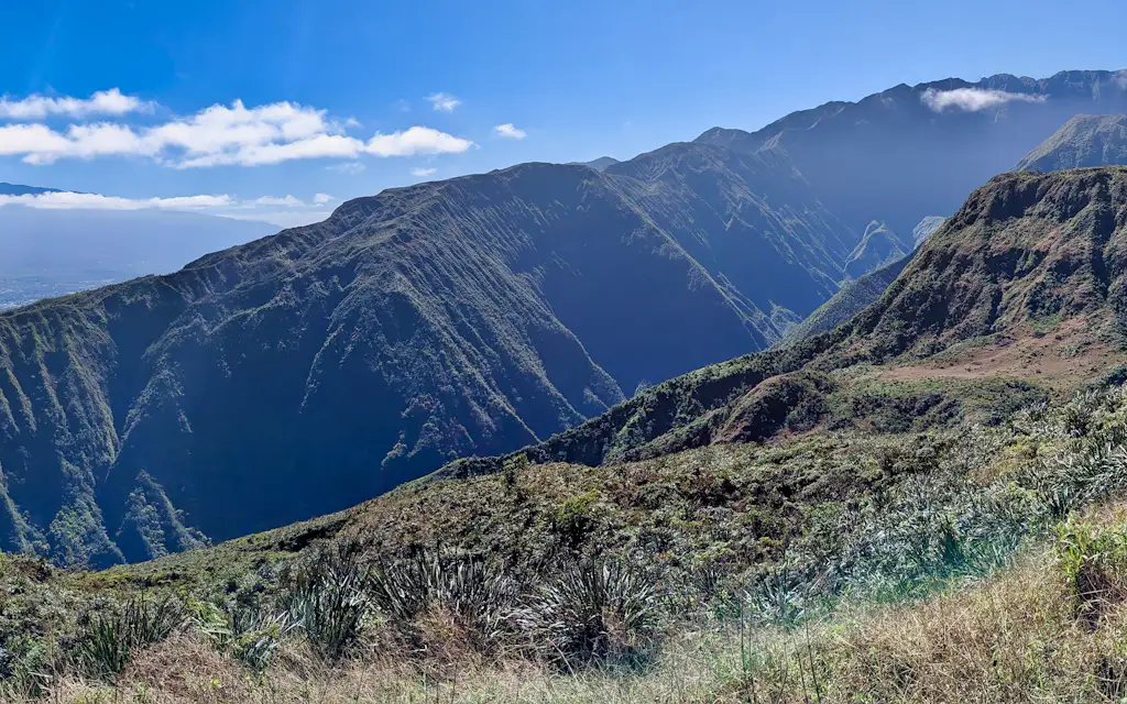
Views of the West Maui Mountains from the top
The reason you climbed is the view, and on a clear morning it earns every step. From the Lanilili summit the mountains spread out in every direction - the deeply fluted green walls of Waihee Valley, ridgelines stacking into the distance, and the ocean far below past Kahului. On a clear morning the cloud breaks somewhere beneath you and the whole green spine of the island falls away on both sides at once.
As you pass the open stretches on the way up, look across the valley and you can pick out Makamakaole Falls threading down the far wall, especially after rain. The forest itself is part of the show: this is protected watershed, thick with native and naturalized growth, and the higher you climb the more it feels like the Maui that existed before the resorts. You're standing on Mauna Kahalawai, the older of Maui's two volcanoes, worn down over a couple of million years into exactly these knife edge ridges and plunging valleys - terrain that usually takes a helicopter tour to see from the inside.
The catch, again, is cloud. The summit is often socked in by late morning, which is the entire argument for the early start - and for turning around honest if the top is grey. A view you can't see isn't worth a twisted ankle on the way back down.
Best for: big view hikers, photographers, anyone who wants the West Maui Mountains without a chopper · The catch: clouds win after late morning · The move: summit before 9-10 am for the clear window.

Photo: Roberto Nickson on Unsplash
06
When to go and what to bring
Timing this hike is really about two things: the hour and the forecast. Early morning is the only reliable answer - it's the difference between a clear summit with parking and a foggy one with a mile of extra road walking. The season just tunes the odds around that.
When to hike the Waihee Ridge Trail
By 7-8 amThe only real answer
Clear summit, open parking, soft light, and you're back down before the heat. This is a morning hike or it's a gamble.
Winter (Dec-Mar)Green and wet
The forest is lushest and the streams run, but mud and low cloud are likelier. Watch the forecast and pick the clear morning.
Summer (Jun-Sep)Drier and hotter
Firmer footing and better odds at the view, at the cost of a hotter, more exposed climb. Start right at the gate.
After heavy rainMaybe skip it
The switchbacks turn to slick red clay and the summit socks in. Give it a day - the view is the whole point, and you won't get it.
Winter (December to March) makes the forest its lushest and the falls run hardest, but mud and low cloud get likelier; summer is drier underfoot with better odds at the views, at the cost of a hotter climb. Either way, you're climbing into the weather that lives on these mountains, so pack for it.
There's no bad month, exactly - just better and worse mornings within each, which is why the forecast beats the calendar. Check the mountain forecast the night before, not the resort strip one; the windward mountains catch cloud and rain that never reach sunny Kihei or Lahaina. A clear morning in any season beats a perfect afternoon, when the summit is usually gone and the lot long full.
The kit is simple. Bring more water than feels reasonable - a daypack with two to three liters is about right, since there's none on the trail - plus a packable rain shell for the summit cloud and a light layer for the breeze up top. Skip the trekking poles unless your knees ask for them on the way down, but do bring a hat and sunscreen for the exposed lower stretches - the sun finds you there even on a morning when the summit is buried in cloud.
What to bring up the ridge
Grippy shoesNot sandals
Trail runners or boots. The red mud and wet roots on the switchbacks are slick, and the descent is where people go down.
2-3 liters of waterNo taps up there
No water, and long stretches with no shade; the climb does the rest. Bring more than feels reasonable, especially in summer.
A rain shellThe ridge makes weather
You're climbing into the cloud that lives on the West Maui Mountains. A packable shell turns a cold, wet summit into a fine one.
A layer and a snackCooler up top
The summit is breezy and noticeably cooler than the lot. A light layer and a bar at the bench make the view last longer.
07
Safety and respecting the Waihee Ridge Trail
This is a safe, well traveled hiking trail, but it has its honest hazards, and they're all about footing and weather. The switchbacks and the concrete start get genuinely slick when wet, so after heavy rain the trail gets muddy and the smart move is to give it a day - slick red clay plus a steep grade is how ankles get turned. Watch the mountain forecast, not just the beach one; it can be sunny in Kihei and pouring on the ridge.
There's no shade for long stretches and no water anywhere on the trail, so the two most common problems out here are dehydration and people slipping on the descent. Tell someone your plan, since cell service is spotty, and turn around honest if the summit is socked in - the view is the whole point. There's no ranger and no signal for most of the climb, so you're your own safety net: carry enough water, mind your footing on the descent, and don't chase a summit that's already vanished into cloud.
And treat the place with respect. This is protected watershed forest above a town that depends on it, so stay on the trail, pack out every wrapper, and leave the plants and rocks where they are. For where to base yourself, the where to stay in Maui guide sorts the regions, and the nearby Iao Valley walk makes an easy pairing for the same morning. If you want the bigger picture of where this hike sits among the island's trails, read our best hikes in Maui guide next.
FAQ: Waihee Ridge Trail Maui
How long does it take to hike the Waihee Ridge Trail?
Most hikers take two and a half to three hours round trip for the ~4.5 miles. A fit pace runs about 75 minutes up to the Lanilili summit and 45 minutes back down, but the climb is relentless and the top is worth lingering at, so plan for the longer end and start early.
Is the Waihee Ridge Trail dog and kid friendly?
Leashed dogs are allowed, and active older kids who hike regularly handle it fine - it's steep but short. Little ones and anyone unsteady on slick ground will struggle on the concrete ramp and the muddy switchbacks, so judge by stamina and footing, not just age.
Do you need a permit or reservation for the Waihee Ridge Trail?
No - it's free with no reservation. Waihee Ridge is a Na Ala Hele state trail, open to the public from 7 am to 7 pm daily. Unlike Iao Valley or Haleakala, there's no entry fee, parking fee, or advance booking; you just need to beat the lot filling up.
Are there bathrooms at the Waihee Ridge trailhead?
No facilities at all - no restrooms, no water, no shop. The trailhead is a gravel lot and a sign. Use the bathroom and fill your bottles in Wailuku or Kahului before you make the drive up Maluhia Road.
What else is near the Waihee Ridge Trail?
Iao Valley and Central Maui are the easy pairing - both are a short drive back toward Wailuku, so you can hike the ridge in the morning and visit the valley after. The scenic, slow Kahekili Highway and the village of Kahakuloa continue north of the trailhead for the adventurous, and Mendes Ranch sits right across the road.
Is the Waihee Ridge Trail too muddy after heavy rain?
Often, yes - give it a day. The switchbacks and the dirt sections turn to slick red clay when it's been raining, which makes the descent the real hazard. The trail also clouds over fastest in wet weather, so a rainy stretch costs you both the footing and the view. Wait for a dry, clear morning.
Disclosure: Some links on this page are affiliate links. If you book or buy through them we may earn a small commission, at no extra cost to you. As an Amazon Associate, we earn from qualifying purchases.


