Map of the Big Island: A Region Guide (2026)
20 min readYndira W. Tonin
A map of the Big Island is the one piece of Hawaii planning people skip, right up until they book a "quick" dinner an hour and a half from their hotel and learn the hard way that this island does not play by small island rules.
The information here was confirmed for 2026.
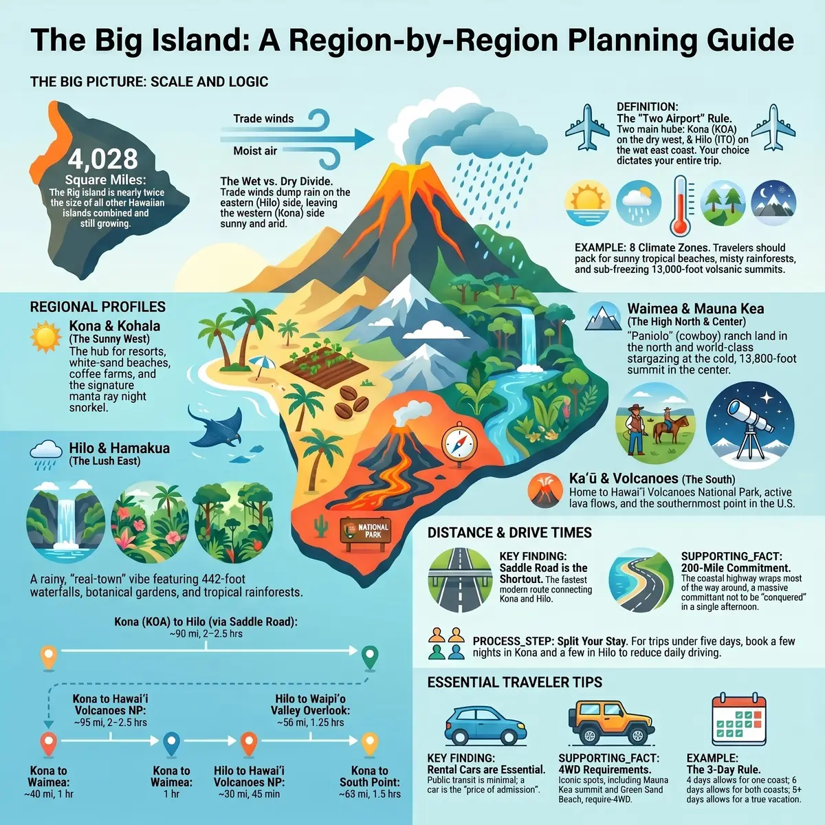
Here is the whole thing in one breath, the Big Island (officially the island of Hawaii) is enormous, about 4,028 square miles, which is bigger than all the other Hawaiian islands combined, with room to spare. It has two airports on opposite coasts, a wet side and a dry side, two 13,000-foot mountains in the middle, and an active volcano still adding new land to the bottom of the map.
So the map matters more here than anywhere else in Hawaii. Learn the regions, Kona and the Kohala Coast in the sunny west, Waimea and the Hamakua Coast up north, Hilo and Puna in the rainy east, Kau (Kaʻū) and Volcanoes down south, and Mauna Kea in the middle, and the Big Island stops looking like a sprawl of unpronounceable place names and starts looking like a plan.
Below is the long version, each region's location, weather, and best things to do, plus how to get around, how long the drives actually take, and how many days you need before you have seen it without spending the whole trip behind the wheel.
Table of Contents
- How big is the Big Island, and how the map works
- The regions of the Big Island at a glance
- Kona and the Kohala Coast, the sunny west side
- Waimea and the Hamakua Coast, upcountry and the green north
- Hilo and Puna, the rainy, green east side
- Kau, South Point, and Hawaii Volcanoes National Park
- Mauna Kea and Saddle Road, the roof of the island
- How to get around the Big Island
- Driving times across the Big Island
- How many days do you need on the Big Island
- Where to base yourself on the map
- FAQ, mapping out your Big Island trip
01
How big is the Big Island, and how the map works
The Big Island earns its nickname. At roughly 4,028 square miles it is nearly twice the size of all the other Hawaiian islands stacked together, and because Kilauea (Kīlauea) keeps erupting, it is the only one of them still growing. The map you look at today has slightly more island on it than the map from a few years ago, which is a sentence you cannot write about Maui.
The trick to reading it is to forget "north south east west" and think in terms of one wet side, one dry side, and two giant mountains in the middle. The trade winds blow from the northeast, dump their rain on the eastern (Hilo) side, and arrive on the western (Kona) side wrung out and sunny. Mauna Kea and Mauna Loa, both around 13,000 feet, sit in the center like a wall, which is why you drive around the island far more than you drive across it.
That single split explains almost everything. Want sunshine, resorts, and snorkeling? West. Want waterfalls, rainforest, and a town with actual character? East. The island famously squeezes in 8 of the world's 13 climate zones, so you can leave a sunny beach in Kona, drive a couple of hours, and find yourself in cold fog at a national park, occasionally in actual snow up top. Pack a jacket. Yes, in Hawaii. (I know.)
Two facts make the rest of the map click. First, there are two airports, Kona (KOA) on the dry west coast, Hilo (ITO) on the wet east, and which one you fly into quietly decides your whole trip. Second, the distances are real. This is not an island you "loop in an afternoon." Hold those two ideas and everything below is just coloring in the regions.
02
The regions of the Big Island at a glance
Before we go district by district, here is the napkin version, the one you would scribble for a friend who leaves Tuesday and refuses to read a full guide.
- Kona (West): dry, sunny, resort and beach country, the main airport, coffee farms, and the manta rays. Where most first timers sleep.
- Kohala (Northwest): the luxury resort coast (the Kohala Coast) on its south end, and wild, green, cliff backed valleys on its north end.
- Waimea & Hamakua (North): cool upcountry ranch land and the green, waterfall laced northeast coast.
- Hilo & Puna (East): the rainy, jungly, real town side, gardens, waterfalls, farmers' markets, and the island's freshest lava.
- Kau & Volcanoes (South): Hawaii Volcanoes National Park, black sand, green sand, and the southernmost point in the United States.
- Mauna Kea (Center): the 13,800-foot summit road, the world's best stargazing, and the Saddle Road shortcut between the coasts.
Notice what the map is telling you, sun and beaches live west, rain and green live east, fire lives south, and the cold lives straight up. That one line explains most of the "but it is raining" complaints from people who based on the wrong coast.
Which side of the Big Island is yours?
Kona & Kohala (West)Our pick
- Best for
- Sun, the best beaches, resorts, manta rays, the main airport
- The catch
- Dry and brown — the waterfalls and jungle are on the other coast
Hilo & Hamakua (East)
- Best for
- Waterfalls, rainforest, gardens, a real town, lower prices
- The catch
- Rains a lot (~130 in/yr) and short on big sandy beaches
Kau & Volcanoes (South)
- Best for
- The national park, black and green sand, otherworldly landscapes
- The catch
- Remote, cool and wet at elevation, very thin on lodging and gas
Waimea & Mauna Kea (Center)
- Best for
- Cool ranch country, some of the best stargazing on Earth, a hop to either coast
- The catch
- No beaches and genuinely cold up high — pack a real jacket
The other thing the cheat sheet hides is that there is no single road that neatly circles this island in a day. The coastal highway does wrap most of the way around, but "most of the way around" here is a 200-plus-mile commitment, not a sitcom length drive. That is the difference between this map and, say, our map of Oahu, where you can meet every region before dinner. Here, the map is not a loop you conquer. It is a set of corners you pick between.
Now, the regions in full.

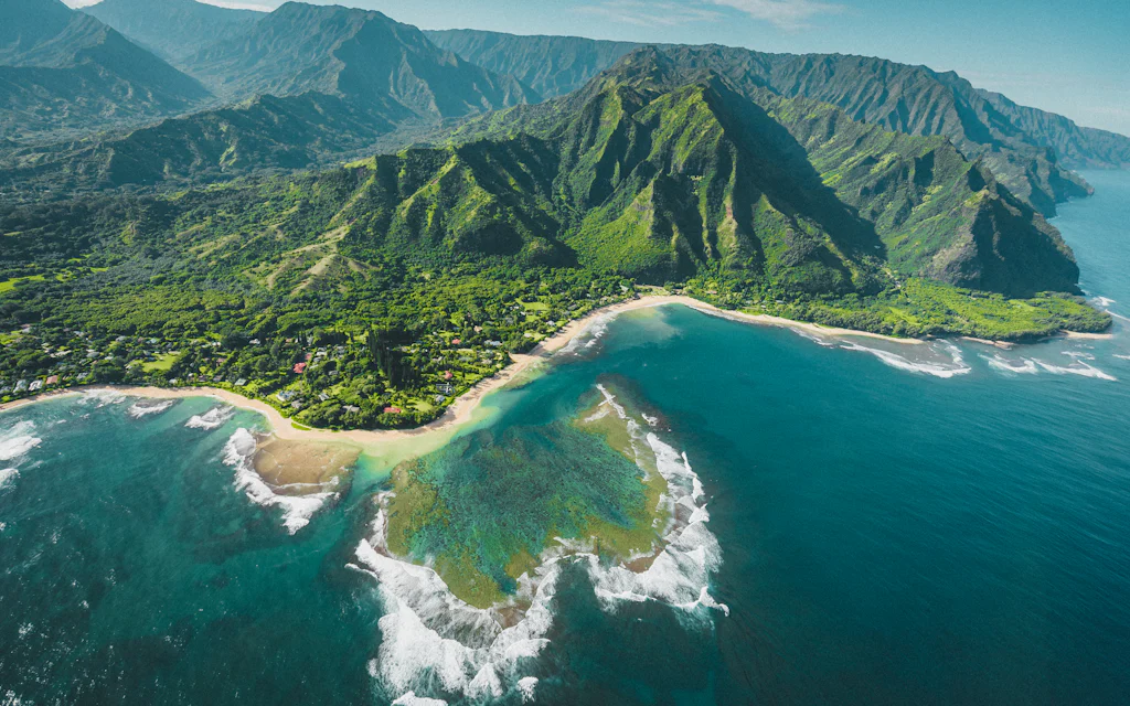
Photo by Oleg Chursin on Unsplash
The Big Island at a glance, the regions, the two airports, the climate split, and the long drives.
03
Kona and the Kohala Coast: the sunny west side
The west side is where most Big Island trips begin, and for good reason, it is the dry, sunny, reliably warm half of the map, with the main airport, the best beaches, and the calmest water. When people picture a Hawaii resort vacation, they are picturing this coast.
Kailua-Kona is the hub, a walkable little town strung along the water with coffee shops, oceanfront restaurants, and the historic Kailua Pier. The surrounding hills are coffee country, this is the only place in the U.S. that grows commercial coffee at scale, and the "Kona" on your morning bag comes from these exact slopes. A farm tour and a free caffeine refill is one of the easier afternoons on the island.
The water here is the headline. Kona's leeward coast is calm and clear, which makes it the island's snorkeling and diving capital. The signature experience is the manta ray night snorkel, you float over a lit patch of ocean while manta rays the size of dining tables loop underneath you to feed. It sounds made up. It is not.
★4.8(6,015)
Big Island Manta Ray Night Snorkel
2.5 hours
Free cancellation
from
$94
Just north, the coast turns into the Kohala Coast, a stretch of black lava fields hiding some of Hawaii's best white sand beaches (Hapuna (Hāpuna) chief among them) and nearly all of the island's luxury resorts. This is the closest the Big Island gets to a Maui style resort row, and it is where you will want to look first for an ocean view room if a pool and lagoon trip is the goal.
One honest note on the scenery, the west side is dry. The lava rock landscape between the airport and the resorts is dramatic, but it is brown, not jungle green, the postcards with the waterfalls were taken on the other coast. Do not pack for rainforest over here. Pack reef safe sunscreen and expect sunshine. For the full rundown of what to actually do over here, our things to do on the Big Island guide goes deeper.

Photo by Seth Yeanoplos on Unsplash
04
Waimea and the Hamakua Coast: upcountry and the green north
Drive uphill from the Kohala Coast and the map changes character completely. Waimea (also called Kamuela) is paniolo country, Hawaiian cowboy ranch land, rolling green hills, cool misty mornings, and the kind of temperature that makes you reach for a sweatshirt you did not think you would need. Parker Ranch, one of the largest cattle ranches in the country, has run these hills for generations. It feels less like Hawaii and more like a high altitude slice of Montana that wandered into the Pacific.
Waimea is also quietly one of the island's best food towns, sitting at the crossroads between the wet and dry sides, close enough to drive to either coast for the day, which makes it an underrated (if beachless) base.
From Waimea the road drops down to the Hamakua Coast, the green northeast shoreline where the trade wind rain finally pays off. This is the green, dramatic Big Island people do not expect, sea cliffs, gulches, waterfalls, and old sugar towns like Honokaa (Honokaʻa).
The crown jewel up here is Waipio (Waipiʻo) Valley, a vast, cliff walled "valley of the kings" with a black sand beach at the bottom and waterfalls down the back wall. The overlook is one of the great views in Hawaii. Note that access down into the valley itself has been restricted in recent years, so plan to admire it from the top unless you have confirmed current rules.
Further along the coast you will hit Akaka Falls, a 442-foot waterfall reachable by a short paved loop, one of the highest reward, lowest effort stops on the entire map. The Hamakua Coast is where you slow the car down, accept that you will stop every ten minutes, and stop apologizing for it.

Photo by Kanoa Leong on Unsplash
05
Hilo and Puna: the rainy, green east side
If Kona is the island's resort, Hilo is its hometown. This is the largest town on the east coast, the rainiest city in the United States (around 130 inches a year), and, partly because of all that rain, the most genuinely charming place on the island. The downtown is a walkable grid of old plantation era storefronts, a knockout farmers' market, and not a resort in sight.
All that water makes the east side spectacularly green. Rainbow Falls sits practically in town. The Liliuokalani (Liliʻuokalani) Gardens and a string of botanical gardens line the coast. And Hilo's beaches, while smaller, include calm spots like Richardson's, where you can actually snorkel off a black sand shore.
The trade off is right there in the rainfall number, you will get wet. Hilo rain tends to come in bursts rather than all day gloom, but it earns its 130 inches honestly. Pack a packable rain jacket and adjust your expectations from "tan" to "thrive."
South of Hilo, the Puna district is the island's frontier, the youngest, rawest land on the map, where lava flows have rearranged the coastline within living memory. This is the home of geothermally heated tide pools, the Kehena black sand beach (the famous Sunday drum circle one), and roads that occasionally just end where the lava decided they should. Puna is offbeat, a little wild, and worth a half day for travelers who want to see the newest ground in the United States. For the full breakdown of the island's volcanic beaches, we wrote a whole black sand beach guide.
06
Kau, South Point, and Hawaii Volcanoes National Park
The southern bottom edge of the map is the strangest and most spectacular stretch on the island, and the one most day trippers shortchange.
Anchoring it is Hawaii Volcanoes National Park, where you can stand at the rim of Kilauea, one of the most active volcanoes on earth, walk through a lava tube, and, when there is an active eruption, watch the caldera glow after dark. It is the single most extraordinary thing on this map, and it deserves more than a rushed hour. Check the official National Park Service eruption updates before you go, because the show changes by the week.
★4.6(575)
Big Island, Hawaii: Volcanoes National Park Safari
55 minutes
Free cancellation
from
$379
West of the park, the Kau district runs out to Ka Lae (South Point), the southernmost point in the United States, a windswept cliff where the brave (or foolish) leap into deep blue water. From there it is a rugged hike to Papakolea (Papakōlea), one of only a handful of green sand beaches on the planet, its color coming from olivine crystals in the old cinder cone. Nearby, Punaluu (Punaluʻu) is the famous black sand beach where green sea turtles haul out to bask on the dark sand.
This whole southern stretch is remote, long drives, few services, and thin lodging, which is exactly why it stays uncrowded. A small group day tour is the low stress way to see the park and the black sand without doing the navigating yourself. You will find more detail in our things to do on the Big Island roundup.

Photo by Alex Wolfe on Unsplash
07
Mauna Kea and Saddle Road: the roof of the island
Straight up the middle of the map sits Mauna Kea, at about 13,800 feet, the tallest mountain in Hawaii and, measured from its base on the ocean floor, the tallest on Earth. It is also one of the best places to stargaze in the Northern Hemisphere, which is why the summit bristles with giant observatories run by a dozen different countries.
You do not casually drive to the top. The summit air is thin and cold (summit temperatures can drop below freezing, and snow is common in winter, yes, in Hawaii), the upper road is steep gravel that rental contracts often forbid, and altitude sickness is a genuine risk. Most visitors stop at the Visitor Information Station around 9,200 feet to acclimatize and catch the stars, which is plenty.
If you want to actually reach the summit for sunset and the stargazing afterward, the sane way is a guided Mauna Kea summit and stars tour, they handle the 4WD, the parkas, and the timing, and you handle the gawking. Bring layers regardless. A packable insulated jacket is the difference between awe and misery up there.
Connecting all this is the Saddle Road (Daniel K. Inouye Highway), the cross island shortcut that runs through the gap between Mauna Kea and Mauna Loa. Once a white knuckle goat track that rental companies banned, it is now a smooth, modern highway and by far the fastest way to cross from Kona to Hilo. It is also a genuinely surreal drive, you climb from sea level into a high altitude moonscape and back down the other side in under an hour.
08
How to get around the Big Island
Let us be blunt, you need a rental car on the Big Island. This is not Waikiki, where you can walk to dinner and bus to the beach. The island is huge, the public transit (the Hele-On bus) is minimal and slow, and the best stuff is spread across hundreds of miles. Renting a car here is not a convenience, it is the price of admission.
The upside, if you are coming from Oahu, parking out here is mostly free and mostly easy. The grief on the Big Island is not finding a spot, it is the distance to the spot. You trade the parking garage tax of a city for long, gorgeous, occasionally gas station free stretches of highway, which is a trade most people are happy to make once they stop expecting a quick hop.
A few map reading notes that save real time,
- Saddle Road is your friend. It is the fast Kona, Hilo connector and modern now. Ignore old advice that it is forbidden or dangerous.
- Gas up before the empty stretches. Kau and the south are long on scenery and short on gas stations.
- Some roads need 4WD or are off limits to rentals, the Mauna Kea summit road and the South Point/Green Sand spur among them. Read your rental contract.
If you would rather not drive the long haul days yourself, a guided multi region day tour is the efficient way to see a big slice of the map in one go, waterfalls, black sand, a lava tube, and the volcano in a single loop, with someone else navigating.
Whatever you choose, build every day around two facts, there are two coasts an island apart, and the mountains in the middle mean you go around far more than across. Plan in half island chunks, not "we will just pop over."
09
Driving times across the Big Island
Here is where the map humbles people. These are rough one way driving times, not "we got distracted by a waterfall" times, just car moving times.
| Route | Distance | Drive time |
|---|---|---|
| Kona (KOA) → Kohala Coast resorts | ~30 mi | 35 min |
| Kona → Waimea | ~40 mi | 1 hr |
| Kona → Hilo (via Saddle Road) | ~90 mi | 2 to 2.5 hr |
| Kona → Hawaii Volcanoes NP | ~95 mi | 2 to 2.5 hr |
| Kona → South Point | ~65 mi | 1.5 hr |
| Hilo → Hawaii Volcanoes NP | ~30 mi | 45 min |
| Hilo → Waipio Valley overlook | ~50 mi | 1.25 hr |
| Kona → Mauna Kea Visitor Station | ~50 mi | 1.5 hr |
The pattern is the whole lesson, nothing is quick here, and the two coasts are a half day round trip apart. A "let us see the volcano from Kona and be back for dinner" plan is five plus hours in the car for one stop. That is not a day trip. That is a hostage situation with nice views.
This is also why so many people are caught off guard. Coming from a compact island like Oahu, or even from our map of Maui guide, where the drives feel long, the Big Island operates on a different scale entirely. Respect the distances and the island rewards you. Fight them and you will spend your vacation watching mile markers.
10
How many days do you need on the Big Island
You can see the headline sights of the Big Island in four days. You can enjoy them in six. You can actually relax in eight or more.
Here is the honest math. Four days gets you one coast done well, say, Kona's beaches and the manta rays, plus a long day down to Volcanoes and the south. Six days lets you add the Hilo side, the Hamakua waterfalls, and a Mauna Kea night without sprinting. Eight plus means you stop checking boxes and start having a vacation.
Now the one strong opinion I will inflict on you, backed by the drive times above, do not try to do the whole Big Island from a single base on a short trip. People book a beautiful Kona resort, then bleed their vacation away on 2.5-hour drives to the volcano and back, twice. The island is too big for that. If you have got under five days, either pick one side and own it (the west is the easier all rounder), or, better, split your stay, a few nights in sunny Kona, a few nights in green Hilo. The 90-mile drive between them becomes a one time scenic crossing instead of a daily tax. Two bases, two different islands, one trip.
The exception, as always, is the traveler who genuinely loves a road day. If watching the climate change through the windshield is your idea of a good time, base wherever and drive your heart out. Just go in knowing the numbers, not discovering them at hour two.
11
Where to base yourself on the map
Match the region to the trip you actually want.
- First timers and beach and resort people: the Kona / Kohala Coast, west side. Sun, the best beaches, the manta rays, the most lodging, the main airport. (Compare Big Island hotels on Expedia (also on Booking.com).)
- Waterfall, rainforest, and real town lovers: Hilo, east side. Greener, cheaper, more local, and close to Volcanoes, though you will trade beach time for rain.
- Splitters who want it all: a few nights Kona, a few nights Hilo. The single best way to see this map without living in the car.
- Stargazers and cool weather fans: Waimea, in the middle and uphill, beachless, but a quick hop to either coast and close to Mauna Kea.
- Volcano first travelers: the Volcano village area, right outside the national park, for glow after dark access and early morning crater walks.
A quick gut check before you book, drop a pin on the three things you are most excited about and notice which coast they cluster on. If two of three are waterfalls and the volcano, do not book a Kona resort and commute east every day, sleep on the green side for part of the trip.
Quick disclosure, since we are on the subject of beaches, we run beach picnics on Oahu, not the Big Island, so this guide is just us being useful, not a pitch. (If your trip also touches Oahu, a sunset picnic for two there starts at $349.) For the bigger picture of which island fits you, our best island to visit in Hawaii guide zooms all the way out, and the official Big Island visitor site is a solid second opinion.
FAQ: mapping out your Big Island trip
How big is the Big Island, really?
About 4,028 square miles, bigger than all the other Hawaiian islands combined, and still growing thanks to ongoing eruptions. It is roughly 93 miles across at its widest, with two airports on opposite coasts. Plan in half island chunks. You cannot loop it in a day.
What are the main regions of the Big Island?
Six broad areas, Kona (sunny west), Kohala (resort coast and green north), Waimea and Hamakua (upcountry and the green northeast), Hilo and Puna (rainy east), Kau and Volcanoes (the south), and Mauna Kea (the center). Sun and beaches are west, rain and waterfalls are east, the volcano is south, and the cold is straight up.
Should I fly into Kona or Hilo?
Kona (KOA) is the better default for most first time visitors, it is nearest the resorts, beaches, and sunshine. Hilo (ITO) is closer to the waterfalls, gardens, and the national park. If you are splitting your stay between coasts, the smart move is to fly into one and out of the other so you never backtrack.
How many days do you need on the Big Island?
Four days for the highlights of one side, six to comfortably see both coasts, and eight or more to relax. Because of the distances, a longer trip pays off more here than on the smaller islands.
Do you need a car on the Big Island?
Yes. The island is too large and spread out, and public transit is minimal, so a rental car is essential for everything beyond your immediate resort. Note that a few roads (the Mauna Kea summit, the Green Sand Beach spur) require 4WD or are off limits to rental cars, check your contract.
What is the drive time from Kona to Hilo?
Roughly 2 to 2.5 hours one way via Saddle Road (about 90 miles), which is the fastest route. Going the long way around the north or south coast takes longer but adds scenery. It is the single most underestimated drive on the island.
Disclosure: Some links on this page are affiliate links. If you book or buy through them we may earn a small commission, at no extra cost to you. As an Amazon Associate, we earn from qualifying purchases.


