Map of Maui: Regions, Towns and Driving Times (2026)
12 min readYndira W. Tonin
A map of Maui splits cleanly into five regions around two volcanoes, West Maui, South Maui, Central Maui, Upcountry, and East Maui, with the North Shore riding the seam between them. Learn the five and every hotel listing, drive time, and weather forecast on the island suddenly makes sense. This guide decodes the whole Maui map, with 2026 drive times and what changed in Lahaina, checked as of July 2026.
01
Maui maps at a glance
Maui is two volcanoes holding hands. The old West Maui Mountains anchor one side, 10,023 foot Haleakala anchors the other, and the flat isthmus between them is why they call it the Valley Isle. Everything on the island is either on a volcano's sunny side, its rainy side, or the valley floor connecting them.
Maui, Hawaii's second largest island, runs 727 square miles, home to about 164,000 residents and zero cities that feel like one and more than 30 miles of swimmable beach spread across 81 accessible beaches, more than any other Hawaiian island. Three airports pin the map, Kahului's OGG in the central valley where nearly everyone lands, named for the pioneering local pilot Bertram Hogg, tiny Kapalua JHM serving the west side by commuter plane, and Hana's airstrip serving the brave.
Every map of Maui you will find draws the same five lines, and the official printable Maui maps on the state tourism site make a good glovebox download. The interactive map below does the same job with live traffic attached, zoom it, save it, and let it remember where the car is parked. Consider this section the overview, the regions below carry the information that decides bookings.
Which Maui is your Maui
West MauiClassic resorts
Kaanapali to Kapalua resort strip, dry and walkable. Lahaina rebuilding with respect.
South MauiSunniest
Kihei condos to Wailea luxury, about 276 sunny days, Molokini offshore.
Central MauiThe hub
The airport, the big grocery run, Iao Valley, and the Maalaea ferry to Lanai.
UpcountryThe mountain
Ranch country at 1,500 to 4,000 feet, Haleakala sunrise above it all.
East Maui + North ShoreThe wild side
Paia surf town, Hookipa windsurfing, then 620 curves to Hana.
Dry side vs wet side
Rain shadow coastsOur pick
south + west
- Kihei about 10 to 12 inches of rain a year
- Roughly 276 sunny days in South Maui
- West Maui slightly wetter in winter
- Where the resorts cluster, on purpose
Trade wind side
east + upcountry
- Hana side measured in feet of rain, not inches
- The waterfalls and jungle bill gets paid here
- Upcountry runs 10 to 20 degrees cooler
- Summit sunrises regularly hit freezing
The regions sort themselves by weather, which on Maui means by volcano shadow. The south and west coasts sit in rain shadows and stay dry and sunny, the east coast catches the trade wind rain and grows the jungle, and Upcountry floats above it all at sweater temperatures. Each region is a different island in miniature, so picking one picks your climate, which is why the map decides more of a Maui trip than any activity list.
02
The regions of Maui, mapped
Six regions, five roads that matter, and one airport in the middle. Here is each piece of the island in the order most trips meet them.
West Maui: Lahaina, Kaanapali, and Kapalua
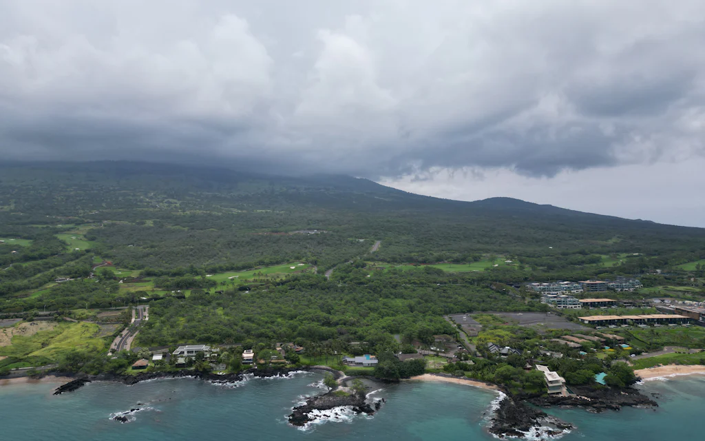
West Maui wraps the old volcano's dry side with the island's most famous resort strip. Kaanapali, Napili, Honokowai, and Kapalua came through 2023 untouched and run at full speed in 2026, three miles of connected beach resorts, two golf resorts up north, and the JHM commuter airport in between.
Lahaina town itself is rebuilding from the August 2023 wildfire, and visiting West Maui in 2026 means holding both truths at once. Front Street reopened its first walkable stretch, the harbor resumed limited daytime operations in December 2025, about 220 destroyed homes have been rebuilt with hundreds more underway, and the county aims to reopen Front Street to through traffic around the fire's third anniversary. The banyan tree survived, is growing new canopy, and remains fenced off with the park around it.
Lahaina and the west side, plainly
The visitor guidance is simple and locals repeat it plainly. Stay out of fenced areas, take no photos of damaged property, fly no drones, and spend money at what is open, which includes the Old Lahaina Luau, back since March 2024 with table service, and the surviving restaurant row at 505 Front Street. The numbers say the help is working, Maui welcomed 231,331 visitors in May 2026, up 18 percent on the year, and West Maui hotels are filling again.
Kaanapali Beach itself anchors the strip, three miles of resort sand with Whalers Village in the middle, and travelers who want the quiet version head north, the forums consistently point first timers seeking calm toward Napili and Kapalua, with Honolua Bay's blue water snorkel bowl just beyond.
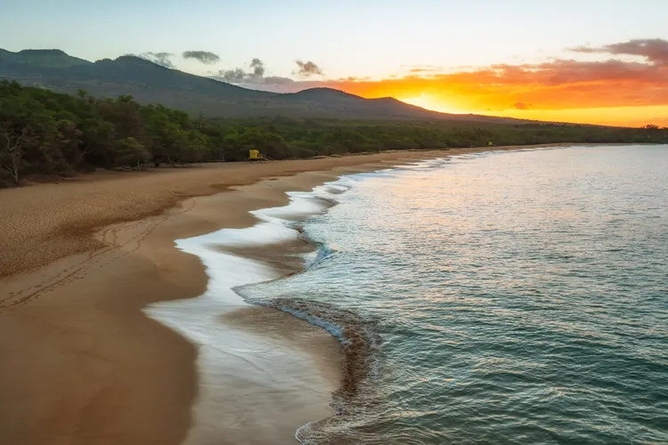
South Maui: Kihei, Wailea, and Makena
South Maui is the sunshine ledger's winner, tucked so deep in Haleakala's rain shadow that Kihei logs roughly 10 to 12 inches of rain a year and about 276 sunny days. The region runs one long coastal road with condos and beaches strung along it, budget friendly Kihei, manicured Wailea, and wilder Makena at the end where the pavement gives up.
Molokini crater sits three miles offshore, a protected marine conservation district since 1977, which is why most snorkel boats leave from this side. Kamaole's three lifeguarded beaches anchor the family end of the map, Wailea's resort row handles the anniversary budgets, and Makena's Big Beach ends the road in state park wilderness where the map runs out of pavement on purpose.
Winter regulars lean south, the north and west sides catch more winter rain while Kihei mostly ignores the season. Whether you base here or just commute for the sunshine, the south side makes the morning snorkel math easiest.
★4.9(2,754)
Maui Eco-Raft Tour: Eye-Level Whale or Dolphin Watching - Lahaina
2 hours
Free cancellation
from
$85
Central Maui: Kahului, Wailuku, and the airport
Central Maui is the valley floor everyone crosses and nobody vacations in, and that is its job. Kahului holds OGG, the big box stores, and the first grocery run, Wailuku holds the county government and the entrance to Iao Valley's green needle and its short hiking trails, and the whole region works as the island's hub.
One 2026 update matters here, the Lanai passenger ferry now sails from Maalaea Harbor on the south edge of the valley, three round trips most days, having relocated after the Lahaina fire. Maalaea is also the harbor half the island's snorkel fleet calls home, which makes the valley the main travel junction on the map whether you sleep here or not.
Use the valley for what it does well, the first grocery stop after landing, the gas fill before Hana, and the plate lunch counters where the island actually eats. The isthmus runs about six miles wide, so crossing it never costs more than fifteen minutes without traffic.
Upcountry Maui: Kula, Makawao, and Haleakala
Upcountry stacks the map's third dimension, ranch and farm country from about 1,500 to 4,000 feet up Haleakala's slopes. Makawao keeps its paniolo cowboy history, Kula grows the lavender, protea, and half the island's produce, and the summit road climbs to 10,023 feet where temperatures run at least 20 degrees colder than the beach and sunrise regularly hits freezing.
The famous sunrise requires a reservation to enter the summit district between 3am and 7am, booked ahead on the national park site. Pack every layer you own, then borrow one more. The reward is watching dawn crack open a crater the size of Manhattan while the beach crowd sleeps two vertical miles below.
Upcountry also features the island's farm tour circuit, lavender at Alii Kula, goat cheese at Surfing Goat Dairy, and the Saturday morning swap meet culture that makes Makawao feel like aloha with boots on. It is the region visitors skip on trip one and build trip two around.
The North Shore: Paia, Haiku, and Hookipa
The North Shore is the seam where the trade winds hit first. Paia, seven miles and about fifteen minutes from the airport, is the former plantation town turned surf bohemia where everyone fuels up before Hana. Hookipa Beach Park just east ranks among the best windsurfing sites on earth, and in winter the outer reef at Peahi, known to everyone as Jaws, throws waves past 60 feet for surfers towed in by jet ski.
This is also the turnstile of the island, every Road to Hana day starts here, which makes Paia's bakery lines the most reliable traffic jam on the map. Baldwin Beach hides in plain sight a mile west of town for anyone who wants north shore sand without the drive, wide, walkable, and guarded on the town end, and Haiku up the hill keeps the rainforest end of the surf culture.
The spots here run on wind season, summer flattens the ocean for swimmers, winter hands it to the professionals, and Hookipa's late afternoon turtle haul out works year round.
East Maui and the Road to Hana
East Maui is the wet, green half of the island with no road through its middle, and the Road to Hana is how you meet it, 52 miles from Kahului, roughly 620 curves and 59 bridges, 46 of them one lane. The drive runs 2.5 to 3 hours nonstop, which nobody does, because Wailua Falls, the black sand at Waianapanapa, and the banana bread are the point.
Past Hana, the map keeps going to Kipahulu's Pipiwai Trail in Haleakala National Park, about 4 hours from Kahului by the park service's own math. Waianapanapa State Park and its black sand beach need a timed reservation booked 30 days out, and Hana town itself stays small and remote on purpose, one of the last unresortified corners of Hawaii, and the region asks for a full day, not a detour.
Make the drive its own day rather than a commute, the adventures out east reward the itinerary that stops often and promises nothing by dinner.
03
Driving times and the interactive map
The major Maui road arteries all meet at the airport, and the drive times below are the honest numbers as of 2026, and the rule that governs them all, add half an hour during morning and evening rush.
Drive times that decide your base
- 115 to 25 min
Kihei, 11 miles
Wailea adds ten more minutes, the shortest airport run on the island
- 240 to 50 min
Lahaina and Kaanapali, 24 to 27 miles
One highway in, add half an hour at rush hour
- 355 to 60 min
Kapalua, 34 miles
The far end of the west side resort strip
- 42.5 hours
Haleakala summit, 37 miles
The park service's own number, switchbacks do the stretching
- 52.5 to 3 hours
Hana, 52 miles
620 curves nonstop, a full day the way it deserves
The forum logs make the rush hour rule concrete, the same Kihei to Kaanapali run that takes 40 minutes at 8am has taken an hour and a half at 5pm, and the morning Wailea to Honolua run beats the afternoon return by half. Drive against the commuter grain and the whole map shrinks.
The self drive audio app crowd covers the same routes with narration, worth the few dollars for the Hana day especially. One more airport fact worth knowing, commuter flights from OGG to Kapalua JHM take twelve minutes and skip the highway entirely, the scenic cheat code almost nobody uses.
West Maui carries the map's one structural problem, a single highway in and out. The Olowalu stretch runs a 45 mph erosion zone where the state shifted lanes inland after waves undermined the road, and a $298 million realignment is planned to move six miles of highway uphill starting around 2028. Until then, the morning flow runs toward Lahaina, the evening flow runs back, and the smart itinerary drives against the grain.
The Maui map from the airport
Tap to open Google Maps with turn-by-turn directions.
04
Where to base yourself on the Maui map
The forum consensus is blunt, pick one base unless you are staying more than a week. Checkout at 11am and check in at 4pm turns a split stay into a lost half day, so a single Kihei or Kaanapali base with day trips is the standard first timer play, and the 5 nights south plus 3 nights west split only starts making sense past 8 nights.
Base south vs base west
South Maui baseOur pick
Kihei or Wailea
- Sunniest coast on the island
- Closest to Hana and Haleakala starts
- Kihei condos keep budgets honest
- Winter regulars' pick
West Maui base
Kaanapali to Kapalua
- Walkable resort strip living
- Whalers Village without driving
- Summer shines, winter rains more
- One road in, drive off peak
The roads decide more than the resorts do, and the budget geography repeats on both coasts. Condos cluster in Kihei on the south side and Honokowai through Napili on the west, the luxury tier lives in Wailea and Kapalua, and winter planning leans south for the drier sky. Soft demand in 2026 has vacation rentals discounting, which the regulars call the best base bargain on the island.
A rental car is close to mandatory, the shared airport shuttle runs about $86 a person each way, and the only carless play is staying put in a walkable pocket of Kaanapali or Wailea. Everyone else budgets the car, takes the forum tips, and lets the map help plan the days, one region's attractions per day, sunshine side as the fallback. Families add one more rule, book the base within a short walk of a lifeguarded beach and half the vacation plans itself.
FAQ: mapping out your Maui trip
How many days do you need to see Maui?
Five full days covers the map, seven breathes. One day each for a beach region, the Road to Hana, Haleakala, and the west side, then margin for the day the ocean wins. Shorter trips should pick two regions and skip the rest without guilt, the island rewards depth over coverage.
What is the best area to stay on Maui for first timers?
Kihei for value, Wailea for luxury, Kaanapali for the classic resort strip. South Maui edges the west for sunshine and drive times to Hana and Haleakala, the west edges the south for walkable resort life, and both offer the full Maui experience. Read the reviews with a map open and the pattern teaches itself.
Can you drive around the whole island of Maui?
Technically around Haleakala, practically no. The back road past Kipahulu runs rough, remote stretches most rental agreements exclude, and the West Maui loop's far side is narrow and slow. Treat both as out and back drives.
Do you need a rental car on Maui?
Almost certainly yes. There is no rail, the bus skips the sights, and the island's best activities scatter across 50 mile drives. The exception is a resort stay where the pool is the itinerary.
Where is Maui on a map of Hawaii?
Maui, Hawaii is the second island from the southeast, between the Big Island and the Molokai and Lanai cluster, about a 40 minute flight from Honolulu and the easiest second island to visit from Oahu. Its central position is why day trips to Lanai run by ferry from Maalaea.
We run beach picnics on Oahu, not Maui, no stake in where you land. Learn the five regions and the map of Maui stops being geography and starts being a plan, sunny side for the tan, wet side for the waterfalls, and the mountain for the sunrise you will describe for years.
Read this next: Where to stay in Maui, region by region.
Cover photo, Logan Voss on Unsplash.
Disclosure: Some links on this page are affiliate links. If you book or buy through them we may earn a small commission, at no extra cost to you. As an Amazon Associate, we earn from qualifying purchases.