Map of Kauai: Regions, Drive Times, and Where to Stay
20 min readYndira Wember Tonin
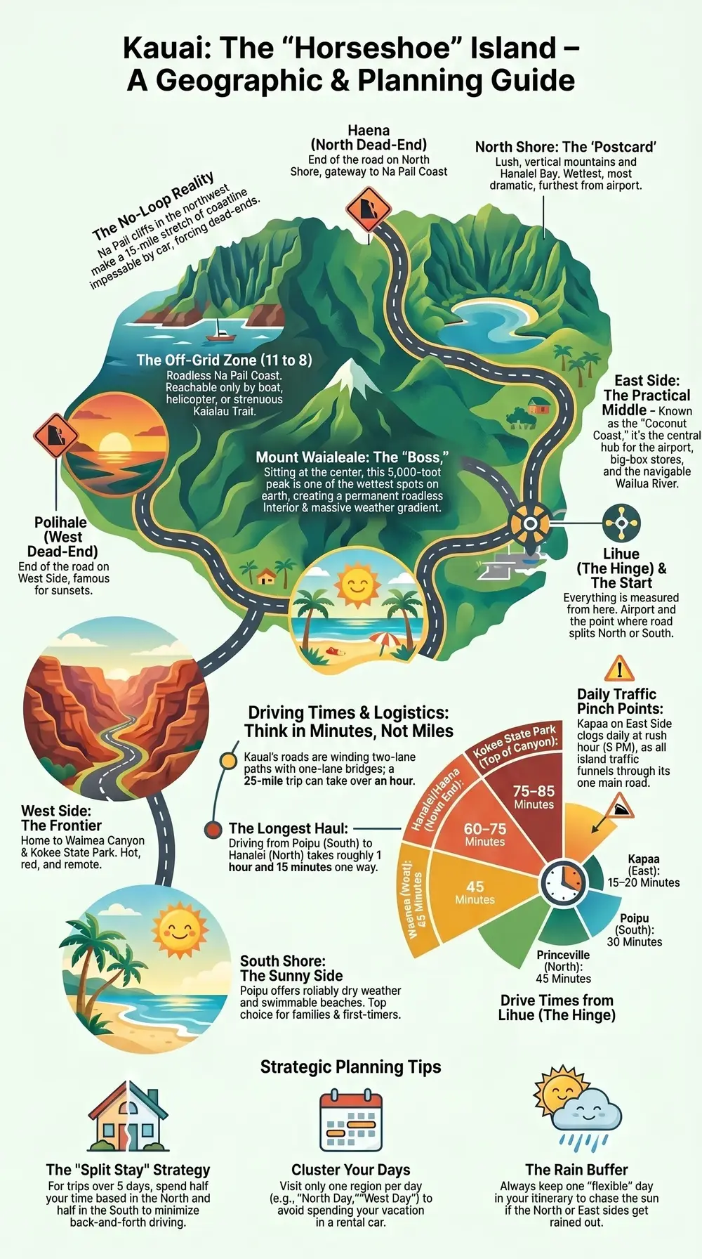
A map of Kauai looks deceptively simple: one main road, hugging the coast, with the island's green heart in the middle. Then you notice the road just... stops. Twice. Because the Na Pali Coast on the northwest side is so sheer and folded that no road has ever been built across it, which means you cannot drive all the way around Kauai. You drive out, and you drive back the same way, and you make your peace with it.
Kauai is about 25 miles across and 33 miles top to bottom — small enough to feel knowable, big enough to eat your week if you base yourself wrong. The whole island wraps around a single 5,000-foot mountain, Waialeale, which is one of the wettest spots on earth and the reason everything here is so aggressively green.
Read the map clockwise from the airport and it sorts itself into four drivable regions plus one you can only reach by boat, foot, or helicopter. Get the geography straight before you book a hotel and you will save yourself hours in the car. Get it wrong and you will spend your vacation re-driving the same stretch of Kuhio Highway, narrating your regret to a rental Jeep.
This is the orientation guide: how the map of Kauai actually works, what lives in each region, how long the drives really take, how many days you need, and where to base yourself so the island comes to you instead of the other way around.
Table of contents
- How to read a map of Kauai
- The five regions of Kauai at a glance
- The East Side: Lihue and the Coconut Coast
- The North Shore: Princeville, Hanalei and the end of the road
- The South Shore: Poipu and the sunny side
- The West Side: Waimea, the canyon and Kokee
- The Na Pali Coast: the part you cannot drive to
- Getting around Kauai
- Driving times across Kauai
- How many days do you need on Kauai
- Where to base yourself on the map
- FAQ: mapping out your Kauai trip
How to read a map of Kauai
Start with the one fact that governs everything else: there is no loop road. Kauai is shaped like a slightly squashed circle, and the highway tries to wrap around it but gives up at both ends, defeated by the Na Pali cliffs in the northwest. The road from the south dead-ends at Polihale on the west side. The road from the east dead-ends at Haena on the north side. Between those two dead-ends is 15 miles of impassable coastline and your only crossing options are a boat, a kayak, a strenuous trail, or a helicopter.
What that means in practice: Kauai is not a circle you drive around, it is a horseshoe you drive into and back out of. Everything is measured from Lihue, the airport town in the middle of the east coast, because that is where the road splits — one branch curls north and west toward Hanalei, the other drops south and west toward Poipu and Waimea.
The middle of the island is the other thing the map hides. That green blank space is not empty, it is unreachable — a roadless interior of mountains, the Alakai Swamp, and the canyon, drained by rivers that fan out to the coast. You do not cut across Kauai. There is no shortcut. The mountain in the middle is the boss and the road is just a guest hugging the edge.
So a good mental map of Kauai is a clock face with the center painted out. Lihue sits at 3 o'clock. Drive counter-clockwise (north) and you reach Kapaa, Princeville, Hanalei, and the end of the road at Haena around 11 o'clock. Drive clockwise (south) and you hit Poipu near 5 o'clock, then Waimea and the canyon turnoff around 8 o'clock. The stretch from 11 to 8 — the whole top-left — is the Na Pali, and it is gloriously, permanently off the grid.
The five regions of Kauai at a glance
Kauai officially splits into five regions, and the map makes more sense once you can name them. Four you can drive to. One you mostly cannot.
The quick version, clockwise from the airport: the East Side (Lihue and the Coconut Coast) is the central, practical middle; the North Shore (Princeville and Hanalei) is the lush, dramatic, rainier postcard; the South Shore (Poipu) is the sunny, resort-friendly, reliably-dry side; the West Side (Waimea and Kokee) is the hot, red, frontier edge with the canyon above it; and the Na Pali Coast is the roadless cathedral in the northwest that everyone comes to see and nobody gets to drive.
The five regions of Kauai
East Side (Kapaa / Lihue)Our pick
- Best for
- First or short trips, and anyone who hates long drives — dead center, about 40 minutes to either end of the island
- The catch
- Beaches are good, not jaw-dropping; Kapaa's one road jams at rush hour
North Shore (Princeville / Hanalei)
- Best for
- Jungle, waterfalls, Hanalei Bay, and the most dramatic scenery in the state
- The catch
- The wettest region — winter can mean real gray days; furthest from the airport
South Shore (Poipu)
- Best for
- Sun, swimmable beaches, families, and first-timers who want guaranteed weather
- The catch
- Less lush and dramatic; about 1.5 hours from the North Shore
West Side (Waimea / Kokee)
- Best for
- Waimea Canyon, the Kokee lookouts, big empty beaches, and the island's best sunsets
- The catch
- Hot, dry, and remote; last gas for a while; very few places to stay
Na Pali Coast
- Best for
- The signature fluted cliffs — seen by boat, the Kalalau Trail, or helicopter
- The catch
- No road, ever — you cannot drive here, and winter swell shuts the boats down
Each region has a personality and a trade-off, and the rest of this guide walks them one at a time. The thing to hold in your head now is the weather gradient, because it drives every other decision. Kauai's north and east catch the trade winds and the rain, which is why they are so green and why Hanalei can be misting while Poipu is in full sun. The south and west sit in the mountain's rain shadow and stay dry and hot.
So the map is also a weather map. If your trip is about beaches and sun, your center of gravity is the south. If it is about jungle, waterfalls, and that jagged-green-cliff Kauai you saw in the movies, it is the north. Most people want both, which is the whole reason the "where to base yourself" question gets complicated later.
The East Side: Lihue and the Coconut Coast
The East Side is where you land, where you rent the car, and where a lot of people quietly end up basing themselves without ever planning to. It runs from Lihue north through Wailua and Kapaa — a stretch nicknamed the Coconut Coast — and its single best quality is that it is in the middle. From here, the north shore and the south shore are each about a 40-minute drive, which means you are never committing to a brutal haul in either direction.
Lihue itself is not a resort town, it is a functional one: the airport, the big-box stores, the Costco where everyone provisions, and the harbor. You do not come to Kauai for Lihue, but you will pass through it constantly because it is the hinge the whole island swings on.
Kapaa, a few miles north, is the East Side's actual personality — a walkable old town of local restaurants, coffee, and a flat coastal bike path. Just inland sits the Wailua River, the only navigable river in Hawaii, with Opaekaa Falls and the Fern Grotto and a steady traffic of kayak tours. The catch with the East Side is honest: the beaches here are good, not jaw-dropping, and Kuhio Highway through Kapaa is the island's one reliable traffic jam, especially at 5pm when everyone on Kauai apparently decides to drive through Kapaa at once.
For a fuller rundown of what fills the days here, the things to do on Kauai guide goes deeper than a map post should. For now, file the East Side under "central, convenient, slightly less postcard" and move on.

Photo: Irina Zhikh on Unsplash
Kauai the horseshoe island: why the road doesn't loop, the regions, and drive times.
The North Shore: Princeville, Hanalei and the end of the road
The North Shore is the Kauai of the brochures, the helicopter shots, and at least one dinosaur movie. Drive north from Kapaa and the island gets greener, the mountains get more vertical, and somewhere around the Princeville turnoff you will physically feel the rental car fill with anticipation.
Princeville sits on the cliffs — a planned resort community with golf, ocean-view hotels, and the kind of manicured calm that some travelers love and others find a little too much like a gated brochure. Just past it the road drops down into Hanalei, and this is the one. Hanalei Bay is a two-mile crescent of sand wrapped by mountains that look digitally enhanced and are not, a waterfall-streaked wall of green that hangs over the town like a backdrop someone forgot to take down.
Past Hanalei the road narrows, crosses a series of one-lane bridges that enforce a kind of forced politeness, and ends at Haena, the trailhead for the Kalalau Trail and the gateway beach for the Na Pali. The end-of-the-road beaches here — Kee among them — are where the drivable island runs out. Our Kee Beach guide covers the reservation system you now need to get out here, because the state finally capped the crowds. The Haena State Park page has the current rules; check them before you go, because turning up without a reservation gets you turned around.
The honest catch with the North Shore is the rain. It is the wettest, greenest, most dramatic region precisely because it gets dumped on, and a north-shore-based trip in winter can mean genuine days of gray. That is the trade for the most beautiful coastline in the state. Most people take it.
The South Shore: Poipu and the sunny side
If the North Shore is the drama, the South Shore is the reliable good time. Poipu sits in the rain shadow on the dry southern coast, which means while Hanalei is misting, Poipu is very likely in the sun — and that single fact makes it the default base for families, first-timers, and anyone who flew a very long way and would like to actually see the beach they booked.
Poipu's beaches are the island's most swimmable and most consistent: protected coves, gentle water, a resident population of monk seals that haul out on the sand and get roped off by volunteers, and reliable snorkeling right off the shore. Poipu Beach Park itself is the kind of place you can take a toddler and a grandparent on the same afternoon. Just up the road, Old Koloa Town gives you the obligatory plantation-era main street with shaved ice and shops.
The South Shore's trade-off is the mirror of the North's. It is sunny, dry, and easy, which also means it is less lush and less dramatic — you are not waking up under a wall of waterfalls. It is also further from the Na Pali and Hanalei, which sit about an hour and 15 minutes away at the far end of the island. Snorkelers who want guaranteed-calm water without a boat can do a guided shore snorkel right in Poipu, which is the kind of low-stakes win the south side does best.
For couples weighing Kauai against the other islands, our Hawaii honeymoon guide puts Poipu's easy-sun appeal next to the North Shore's drama. On the map, just remember: south equals sun, north equals scenery.

Photo: Kevin Doran on Unsplash
The West Side: Waimea, the canyon and Kokee
Keep driving past Poipu and the island changes character entirely. The West Side is Kauai's frontier — hotter, drier, redder, and emptier, a stretch of old plantation towns and the last gas you will see for a while. This is the least-visited drivable region and also the location of the single most spectacular thing you can reach by car: Waimea Canyon.
Mark Twain reportedly called it the Grand Canyon of the Pacific, and while every canyon on earth gets compared to the Grand Canyon, this one has the decency to also be striped in red, green, and purple and laced with waterfalls. The road climbs from the hot coast at Waimea town up into Waimea Canyon State Park and keeps going to Kokee State Park at the top, where the temperature drops, the air smells like a different island, and a couple of lookouts stare straight down into the back of the Na Pali valleys. People show up in beach clothes and spend the whole overlook visibly shivering and regretting it. Bring a layer.
At the very end of the southern road is Polihale, a vast, wild, unpatrolled beach with no facilities, dangerous water, and the best sunset on the island — reachable by a rough dirt road that rental contracts technically forbid and everyone drives anyway. The West Side's whole deal is that it feels like the edge of the map, because it is. After Polihale, the next thing is the Na Pali, and there is no more road.

Photo: Roberto Nickson on Unsplash
The Na Pali Coast: the part you cannot drive to
Here is the region that explains the whole island. The Na Pali Coast is 15 miles of fluted green cliffs rising 4,000 feet straight out of the Pacific on the northwest shore, and it is the reason the map of Kauai has two dead-ends instead of a loop. No road crosses it. No road ever will. You reach it three ways: by boat, on foot, or from the air.
By boat is how most people do it, and it is the one I would prioritize on any first trip. Catamarans and rafts launch from the west and south sides in summer and run the full length of the coast, past sea caves and waterfalls and the kind of scenery that makes a whole boat full of strangers go quiet at the same moment. The water is calmest May through September; winter swell shuts a lot of it down.
On foot is the Kalalau Trail from Haena — 11 miles of muddy, vertical, genuinely serious hiking to a beach you cannot otherwise reach, with the first 2 miles to Hanakapiai doable as a (still strenuous) day hike with a Haena reservation. From the air, a Kauai helicopter tour is the only way to see the roadless interior — the canyon, the swamp, the waterfalls behind Waialeale — in an afternoon, and on an island this folded the splurge earns its keep. You can also see the coast by boat tour from the west side, which pairs naturally with a couple of days based in Poipu.
The Na Pali is the thing people remember about Kauai, and the map's biggest lesson is that you have to plan for it on purpose. It will not happen by accident, because you cannot drive there.
Getting around Kauai
You need a car. This is not negotiable, and it is the first thing to internalize about the map. Kauai has no rail, a thin and slow public bus, and rideshare that ranges from sparse to mythical once you leave Lihue. The island's attractions are spread along that single horseshoe road, and without your own wheels you are stranded wherever your hotel happens to sit.
The main road changes names but not personality. Kuhio Highway (Route 56) runs north from Lihue to Hanalei; Kaumualii Highway (Route 50) runs south and west toward Waimea. Both are two-lane, both wind, and neither is built for speed — there is no H-1-style freeway like Oahu has. The one-lane bridges past Hanalei are a feature, not a bug: they force cars to take turns, and the local etiquette is to let about five to seven cars through before yielding, a small civic ritual you will get the hang of.
Plan around two daily pinch points. Kapaa on the East Side clogs predictably at rush hour because every car on the island funnels through its one main drag. And the north-shore road past Princeville simply cannot be hurried. Budget more time than the mileage suggests, fuel up before the West Side, and accept that on Kauai the drive is part of the destination whether you wanted it to be or not. If your trip also routes through other islands, the map of Oahu and map of Maui guides break down how getting around differs island to island — Kauai is the one where you most need the car and least get to rush.
Driving times across Kauai
Mileage lies on Kauai, so think in minutes. Everything below is measured from Lihue, the airport hinge in the middle, because that is how the island actually works.
- Lihue to Kapaa (Coconut Coast): about 15–20 minutes, longer at rush hour.
- Lihue to Poipu (South Shore): about 30 minutes.
- Lihue to Waimea (West Side): about 45 minutes; add 30–40 more to climb up to Waimea Canyon and Kokee.
- Lihue to Princeville (North Shore): about 45 minutes.
- Lihue to Hanalei and Haena (end of the road): about 60–75 minutes, and the last stretch is slow by design.
- Poipu to Hanalei (south to north, corner to corner): about 1 hour 15 minutes one way — the longest regular drive on the island.
That last number is the one that reshapes trips. A round-trip from a Poipu base to the North Shore is about 2.5 hours in the car before you have done anything, and you will not want to do it daily. The whole drivable island, end to end, is roughly an hour and a half — which sounds tiny until you remember it is an hour and a half of winding two-lane road with a one-lane-bridge finale, not a freeway blast.
A few honest adjustments to make to those numbers. Add a solid buffer for the North Shore in particular, where the road past Princeville narrows, the bridges meter the traffic, and a rain squall can drop everyone's speed to a crawl. Pad the East Side drives at rush hour, when Kapaa's single main road backs up in both directions. And give yourself real time on the West Side: the climb from Waimea town up to Waimea Canyon and Kokee adds 30 to 40 minutes of switchbacks on top of the coastal drive, so a canyon morning is a half-day commitment, not a quick detour.
The upshot is a planning rule, not a complaint: cluster your days by region instead of bouncing across the map. Do the North Shore on a north day, the canyon and West Side on a west day, the south beaches on a south day. Small island, slow roads. Plan in minutes, not miles — and plan in regions, not pins.
How many days do you need on Kauai
Five to seven days is the honest answer, and Kauai rewards the longer end more than the other islands do, because the slow roads and the weather both tax your time.
With three or four days, you can pick a base and see that half of the island well — say, the south and the canyon, or the north and Hanalei — plus one big Na Pali outing by boat. You will leave having seen a real slice and feeling like you owe the island a return trip, which most people do.
With five to seven days, you can do the whole horseshoe without rushing: the North Shore and Hanalei, the South Shore beaches, the West Side canyon, a Na Pali boat tour, and a buffer day for the rain that will, statistically, eat at least one of your afternoons. That buffer matters here more than anywhere — the wettest spot on earth is in the middle of your itinerary, and a flexible day lets you chase the sun to whichever side has it.
If you only have a couple of days because Kauai is a stop on a multi-island trip, that is fine, just be ruthless: pick one side, do one Na Pali outing, and do not try to drive to everything. Trying to "see all of Kauai" in 48 hours is how you spend your one Hawaii vacation looking at the back of a rental Jeep. For help deciding how Kauai fits a wider trip, the best island to visit in Hawaii guide compares it head to head with the others.
Where to base yourself on the map
This is where the map earns its keep, because where you sleep determines how much of your vacation you spend driving. And here is the one strong opinion in this whole guide: on Kauai, do not pick a single base and try to day-trip the entire island. The corner-to-corner drive is 1 hour 15 minutes each way, and a trip built on daily 2.5-hour round-trips is a trip built around your rental car's air conditioning, not the island.
Three sane strategies, depending on your trip:
- Base on the East Side (Kapaa/Lihue) for a short or first trip. Dead center, 40 minutes to either end, no region more than reasonable. You trade postcard-perfect beaches at your doorstep for never facing a brutal commute. The best all-rounder if you are only choosing one.
- Base on the South Shore (Poipu) if you want sun and beaches. Driest, sunniest, most swimmable, family-easy — at the cost of that 1.5-hour reach to the North Shore. Perfect if your trip leans beach and you will day-trip north just once or twice.
- Split your stay, north and south, for five-plus days. Two or three nights in the Hanalei/Princeville area, the rest in Poipu. You halve the long drives, you see both Kauais at their best, and you only pack and unpack once in the middle. For most week-long trips this is the move, full stop. Either way, you can compare Kauai hotels on Expedia (also on Booking.com) across Poipu, Kapaa, and the north shore.
Whichever you choose, match it to the weather gradient: north for green, south for sun, east for the middle ground. (And if your Hawaii itinerary also swings through Oahu, that is the island where we actually work — styling beach picnics on the sand — while on Kauai you are gloriously on your own.)
FAQ: mapping out your Kauai trip
Can you drive all the way around Kauai?
No. The Na Pali Coast on the northwest side has no road and never has, so the highway dead-ends at Haena in the north and Polihale in the west. You drive out to each end and back the same way — Kauai is a horseshoe, not a loop. To see the roadless 15-mile Na Pali stretch you need a boat, the Kalalau Trail, or a helicopter.
How big is Kauai and how long does it take to drive across?
Kauai is about 25 miles across and 33 miles top to bottom. The longest regular drive, Poipu in the south to Hanalei in the north, is roughly 1 hour 15 minutes one way on winding two-lane roads. There is no freeway, so always plan in minutes rather than miles.
What are the five regions of Kauai?
The East Side (Lihue and the Coconut Coast), the North Shore (Princeville and Hanalei), the South Shore (Poipu), the West Side (Waimea and Kokee), and the Na Pali Coast. The first four are reachable by car; the Na Pali is reachable only by boat, foot, or air.
Which side of Kauai is best to stay on?
It depends on your trip. The East Side (Kapaa) is the convenient center and the best single base for a first or short trip. The South Shore (Poipu) is sunniest and best for beaches. The North Shore is the most dramatic but the wettest. For five days or more, splitting your stay between north and south is the way to minimize driving.
Do you need a car on Kauai?
Yes. Public transit is minimal and rideshare is unreliable outside Lihue, while the attractions are spread along one long coastal road. A rental car is essential for getting around Kauai — book it well ahead, since the island regularly runs short in peak season.
Which side of Kauai is sunnier, north or south?
The south and west. Kauai's mountainous interior throws a rain shadow, so the South Shore (Poipu) and West Side (Waimea) stay dry and sunny while the North Shore and East Side catch the trade-wind rain that keeps them so green. If sun is the priority, base south.
Disclosure: Some links on this page are affiliate links. If you book or buy through them we may earn a small commission, at no extra cost to you. As an Amazon Associate, we earn from qualifying purchases.


