Best Hikes in Kauai: 12 Trails Worth the Mud (2026)
20 min readYndira W. Tonin
The best hikes in Kauai range from a flat 20-minute waterfall walk to an 11-mile cliff edge slog that only campers with a permit should attempt - and on the greenest, most folded island in Hawaii, the trail is usually the whole point of the trip. You can see a famous waterfall from your car here, but the canyon rim, the Napali pali edge, and the swamp boardwalk only open up on foot.
This guide sorts every trail worth your morning by region and by effort, with honest distances, the parking and permit rules as they actually stand as of 2026, and where the real risks are. It's written for the hiker who wants the big payoff without guessing which "moderate" hike is secretly a knee destroyer. Kauai rewards the prepared and quietly punishes the casual, so a little planning goes a long way.
Table of Contents
- The best hikes in Kauai at a glance
- Na Pali Coast and North Shore hikes
- Waimea Canyon and Kokee State Park hikes
- East Side hikes: Sleeping Giant and Kuilau Ridge
- South Shore and easy coastal walks
- When to hike Kauai
- What to pack and how to hike Kauai safely
- Where to stay near the trailheads
- FAQ: best hikes in Kauai
01
The best hikes in Kauai at a glance
Kauai packs four completely different hiking worlds into one small island you can drive end to end in about three hours (you can't loop it - the Napali Coast leaves the road a horseshoe, not a circle). The North Shore and Na Pali Coast hold the famous, serious coastal trails; Waimea Canyon and Kokee up west deliver red rock canyon and pali views from cool, high forest; the East Side has the quick ridge climbs near Wailua; and the South Shore has flat sea cliff walks you can do in sandals. Pick the zone that matches your day and your legs, and you cannot really go wrong.
Kauai hiking at a glance
The one thing that trips visitors up is access. Most Kauai trails are free state or forest reserve land you just walk onto, though the Waimea Canyon and Kokee state parks now charge nonresidents an entry and parking fee (Hawaii residents with ID still go free). The exception that needs real planning is the big one - the Napali trailhead at Haena - which runs on a reservation system that sells out fast. More on that below, because it's the single planning step people skip and regret.
The honest sorting question on the Garden Isle is not "which is prettiest" - they're all absurd - it's how much suffering you've signed up for. The easy trails are genuinely easy, often paved or boardwalked. The moderate ones involve real climbing, mud, and a few hours. The hard ones earn their reputation: long, steep, exposed, and unforgiving if the weather turns.
Kauai hikes by effort
Easy (1-3 hours)
- Kuilau Ridge Trail - 3.7 mi, big Mount Waialeale views
- Hoopii Falls - about 2 mi to two swimmable waterfalls
- Mahaulepu Heritage Trail - 4 mi of South Shore sea cliffs
Moderate (3-5 hours)Our pick
- Sleeping Giant (Nounou) - about 3.5 mi to a 360-degree summit
- Canyon Trail to Waipoo Falls - about 3.5 mi in Waimea Canyon
- Hanakapiai Beach - 4 mi on the start of the Kalalau Trail
Hard (half to full day)
- Awaawapuhi Trail - about 6 mi to a Napali pali edge
- Hanakapiai Falls - 8 mi to a 300-foot waterfall
- Kalalau Trail - the full 22 mi, camping permit required
If you only do one hike on the whole island and you're reasonably fit, make it the first two miles of the Kalalau Trail to the Hanakapiai overlook - it's the most Kauai a single morning can hold, and you don't need a backpacking permit for it. If you've got young kids or sore knees, the Kuilau Ridge Trail near Wailua gives you ninety percent of the view for ten percent of the work. Match the trail to the legs you actually brought, not the legs you had at twenty five.
02
Na Pali Coast and North Shore hikes
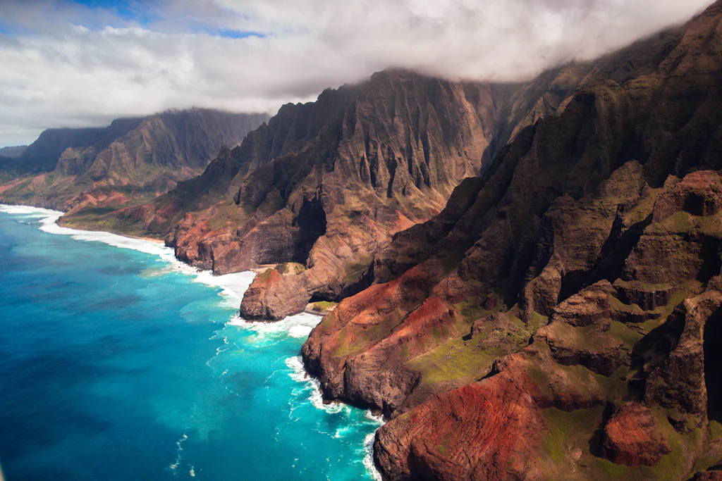
This is the postcard. The North Shore holds Kauai's most famous - and most serious - hiking, anchored by the Kalalau Trail along the roadless Na Pali Coast. The views are the best in Hawaii. The trail is also genuinely dangerous in the wrong conditions, so this is the one stretch of the island where reading the rules matters more than reading the reviews.

Photo: Mark Thomas on Unsplash
The Kalalau Trail
The Kalalau Trail is the undisputed headliner - 11 miles one way from Kee Beach to a remote beach you cannot reach any other way, hugging the fluted Na Pali cliffs the entire route. The full 22-mile round trip is a multiday backpacking trip for fit, experienced hikers with a camping permit, not a casual outing. Most visitors hike the first 2 miles to Hanakapiai Beach and turn around, which is plenty: that opening stretch delivers the iconic coastal view about a mile in.
The catch is access, and it changed again recently. After two Kona low storms hammered the coast in March 2026, the trail closed for landslide repairs; it reopened to permitted hikers on March 19 and to full shuttle and reservation access by mid April 2026, so it's all running normally again now. The lazy way to see the same coastline - the part backpackers earn over two days - is from the water, which costs a few hours instead of a few blisters.
★4.9(547)
Kauai: Na Pali Coast Power Catamaran
4.5 hours
Free cancellation
from
$275
The boat tours leave from the west side and curl right under the cliffs you'd otherwise be sweating along, sea caves and all. It's not cheating. It's just a different, drier kind of earning it.
Day hike vs the full Kalalau Trail
Day hike to HanakapiaiOur pick
What most visitors do
- 4 miles round trip (8 to the falls)
- Haena reservation only, no camping permit
- No overnight gear; back by afternoon
- Still strenuous, still a real hike
Backpack to Kalalau Beach
Fit, experienced hikers only
- 22 miles round trip over 2-3 days
- Camping permit required past mile 2
- Exposed cliff ledges and stream crossings
- A genuine expedition, not a day out
Quick facts: Distance: 4 miles round trip to Hanakapiai Beach; 22 miles round trip to Kalalau · Difficulty: Strenuous · Permit: Haena reservation for the day hike; camping permit past mile 2 · The move: Reserve your Haena slot the minute the 30-day window opens.
How to legally hike the Kalalau Trail now
- 1Step 1
Reserve a Haena slot first
Non-residents must book park entry and/or parking at gohaena.com - there are no walk-ups. The daily cap is 900 people and summer slots disappear within minutes on the rolling 30-day window.
- 2Step 2
Day-hike to Hanakapiai on that reservation
Your Haena booking covers the first 2 miles to Hanakapiai Beach, and the 8-mile round trip up to Hanakapiai Falls. No separate permit is needed to day-hike that far.
- 3Step 3
Past mile 2? You need a camping permit
Anywhere beyond Hanakapiai - to Hanakoa or Kalalau Beach - legally requires a Napali Coast State Wilderness Park camping permit from camping.ehawaii.gov, bookable up to 90 days ahead.
- 4Step 4
Sort parking or ride the shuttle
As of 2026, overnight parking at Haena is for camping-permit holders only; day hikers use the Waipa Park and Ride shuttle (about $40 adult, $25 child), which fills by mid-morning.
Hanakapiai Beach and Hanakapiai Falls
Two miles in, the trail drops to Hanakapiai Beach, where most day hikers stop, and a side trail climbs another 2 miles inland to the 300-foot Hanakapiai Falls - the Hanakapiai Falls Trail is an 8-mile round trip in total, and one of the best waterfall hikes on the island. The falls are spectacular and the pool beneath them is cold and deep.
This is also where Kauai stops being charming and gets serious, so read this part twice. More than 80 people have died at Hanakapiai Beach since the early 1980s, drowned by rip currents that pull straight out to sea - there is no safe swimming here, ever. The bigger killer for hikers is the stream. Hanakapiai Stream floods within minutes from rain you cannot see falling miles upstream, and people have been swept away crossing it. If the water is high, fast, or muddy brown, do not cross. Turn around and wait, or turn back. The waterfall will still be there next trip.
Quick facts: Distance: 8 miles round trip to the falls · Difficulty: Strenuous · Hazard: Flash flood stream crossings; no swimming at the beach · The move: Check the forecast and the stream before you commit past the beach.
Okolehao Trail
For a shorter North Shore climb without the Napali logistics, the Okolehao Trail above Hanalei gives you a sharp, often muddy push up a ridge to wide views over Hanalei Bay and the taro fields. It's roughly 2.5 miles to the first viewpoint and back, steeper than the distance suggests, and gloriously empty compared to the Kalalau crowds. The name comes from the moonshine once distilled from ti root up in these hills, which tells you what people historically did with the privacy.
Quick facts: Distance: About 2.5 miles round trip to the viewpoint · Difficulty: Moderate, steep and muddy · Best for: A North Shore view without a reservation · The move: Go after a dry spell; the clay is treacherous wet.
03
Waimea Canyon and Kokee State Park hikes
Up on the west side, the air turns cool and the land turns red. Waimea Canyon - Mark Twain's "Grand Canyon of the Pacific" - and the high forest of Kokee above it hold the island's best concentration of trails, from easy waterfall view walks to all day pali descents. It's a 45-minute drive up from the coast, it's often 15 degrees cooler than the beach, and the gas station options thin out fast, so fuel up and pack lunch before you climb. For the lookouts, drives, and logistics up here, our Waimea Canyon guide covers the whole park.

Photo: Jason Weingardt on Unsplash
Waimea Canyon and Kokee trails
Canyon Trail to Waipoo FallsModerate
About 3.5 miles round trip to waterfall viewpoints over the red canyon walls. The best payoff-per-effort hike on the west side.
Awaawapuhi TrailHard
About 6 miles to a 2,500-foot pali edge above the roadless Napali valleys. All downhill out, all uphill back.
Nualolo TrailHard
A quieter 8-mile cliff-edge route; loop it with the Nualolo Cliff and Awaawapuhi trails if you have a long day and a shuttle.
Alakai Swamp TrailModerate
A boardwalk across a high-elevation rainforest bog to the Kilohana lookout over Hanalei. Cold, wet, and genuinely otherworldly.
Kukui TrailHard
About 2.5 miles straight down into Waimea Canyon and the same straight back up - roughly 2,000 feet of descent with a river at the bottom.
Canyon Trail to Waipoo Falls
If you do one west side hike, make it the Canyon Trail to Waipoo Falls - about 3.5 miles round trip that delivers more view per step than anything else on the island. You walk along the canyon rim, past a couple of waterfall viewpoints, with the full red and green gorge dropping away beside you. It's exposed and can be hot, but it's not technical, and it pays off the entire way rather than dumping all the reward at a single summit. Pair it with the lookouts on the drive up and you've got a full, satisfying day. For the falls themselves and the island's other cascades, our Kauai waterfalls guide sorts them by how you reach them.
Quick facts: Distance: About 3.5 miles round trip · Difficulty: Moderate, exposed · Best for: Maximum canyon view per mile · The move: Start early before the rim heat and afternoon clouds roll in.
Awaawapuhi Trail
The Awaawapuhi Trail is the west side's big reward: about 6 miles round trip that descends through Kokee forest to a heart stopping 2,500-foot pali edge looking straight down into the roadless Awaawapuhi and Nualolo valleys. The cruel twist is that it's all downhill on the way out and all uphill on the way back, when you're tired. Bring more water than feels reasonable and leave time, because the climb out is the real hike.
Quick facts: Distance: About 6 miles round trip · Difficulty: Hard, big elevation on the return · Best for: The most dramatic pali viewpoint you can reach on foot · The move: Turn around with energy in the tank for the uphill.
Nualolo Trail
Quieter and longer, the Nualolo Trail runs about 7.5 to 8 miles round trip to its own clifftop lookout, and serious hikers loop it with the Nualolo Cliff Trail and Awaawapuhi into a long, spectacular full day circuit. You'll likely have stretches of it entirely to yourself. The loop needs a car shuttle or a road walk between trailheads, so plan the logistics before you start rather than at the dusty junction at hour four.
Quick facts: Distance: About 8 miles round trip, more as a loop · Difficulty: Hard, long and remote · Best for: Solitude and a full day in Kokee · The move: Sort the trailhead shuttle before you set off.
Alakai Swamp Trail
The Alakai Swamp Trail is the strangest hike in Hawaii and worth every cold, soggy step. A boardwalk carries you across a high elevation rainforest bog - one of the wettest places on Earth - to the Kilohana lookout, which on a clear hour frames Hanalei Bay far below and on a cloudy one frames a wall of white nothing. It's otherworldly: stunted ohia, native birds, and mist that comes and goes by the minute. Dress for cold and wet even when the coast is baking.
Quick facts: Distance: About 7 to 8 miles round trip to the lookout · Difficulty: Moderate, very wet · Best for: A landscape you won't see anywhere else in Hawaii · The move: Go on a clear morning for any shot at the Hanalei view.
Kukui Trail
For a short hike that humbles people, the Kukui Trail drops about 2.5 miles straight down into Waimea Canyon - roughly 2,000 feet of switchbacks to the Waimea River at the bottom. The descent is fast and fun. The climb back out, in full sun, is where you learn things about yourself. It's a genuine workout disguised as a moderate distance, so treat the mileage as a polite lie.
Quick facts: Distance: About 5 miles round trip · Difficulty: Hard, all the climb is on the return · Best for: Getting down inside the canyon · The move: Carry extra water and start in the cool of the morning.
04
East Side hikes: Sleeping Giant and Kuilau Ridge
The East Side around Wailua and Kapaa is the practical middle ground - real hikes with real views, ten minutes from a smoothie, no reservation required. These are the trails you do on the day you also want a beach and a plate lunch, and two of them are the best half day climbs on the island.
Sleeping Giant Trail (Nounou)
The Sleeping Giant Trail climbs the Nounou ridge - the long mountain that, from the highway, genuinely looks like a giant lying on his back - to a 360-degree summit panorama over the entire east coast. It's about 3.5 miles round trip with steady switchbacks and a few exposed spots near the top where you'll want to mind your footing. There are three approaches; the Nounou East (Haleilio) trail is the most popular. The legend says the giant Puni ate too much and fell asleep here, which is the most relatable origin story in Hawaiian folklore.
Quick facts: Distance: About 3.5 miles round trip · Difficulty: Moderate, exposed near the summit · Best for: The best East Side view for the effort · The move: Take the picnic up; the summit is the reward.
Kuilau Ridge Trail
The Kuilau Ridge Trail is the island's best easy hike, full stop - a gentle 3.7-mile round trip through fern draped rainforest near Wailua to a picnic perfect ridge with views toward Mount Waialeale, the wettest spot on the planet. It's wide, well graded, kid-friendly, and only as muddy as the past week's rain. If you want the full breakdown - the trailhead, the mud, the Keahua Arboretum stop right beside it - our Kuilau Ridge Trail guide covers it in detail.
Quick facts: Distance: 3.7 miles round trip · Difficulty: Easy · Best for: Families, beginners, and a flat green walk · The move: Pair it with the Keahua Arboretum at the trailhead.
05
South Shore and easy coastal walks
The sunny south is where you hike in the morning and beach in the afternoon. The trails here are flatter and drier than the rest of the island, trading waterfalls and rainforest for sea cliffs, sand dunes, and a genuinely wild coastline most visitors never walk.

Photo: Pete Gontier on Unsplash
Mahaulepu Heritage Trail
The Mahaulepu Heritage Trail runs about 4 miles round trip along the South Shore's undeveloped coast from Shipwreck Beach in Poipu, past lithified sand cliffs, sea arches, and the Makauwahi Cave - the largest limestone cave in Hawaii and a working fossil site. It's mostly flat, fully exposed, and a complete change of scenery from the green interior. The wind out here is constant and the sun is relentless, so this is a hat and water walk, not a midday in flip flops one.
Quick facts: Distance: About 4 miles round trip · Difficulty: Easy, exposed and windy · Best for: Dramatic coast without a climb · The move: Go early, bring a hat, and detour into Makauwahi Cave.
Hoopii Falls Trail
The Hoopii Falls Trail near Kapaa is the low key local favorite - a roughly 2-mile round trip walk through forest and along a stream to two waterfalls with pools you can actually swim in (when the water's calm and clear). It's unmarked in spots and gets muddy, and it's where parts of Jurassic Park were filmed, which the trail does nothing to advertise. Watch your footing near the falls: the rocks are slippery and slick, and people get hurt every year showing off for the camera.
Quick facts: Distance: About 2 miles round trip · Difficulty: Easy to moderate, muddy and unmarked · Best for: A short hike with a swim · The move: Only swim if the stream is low and clear, never after rain.
06
When to hike Kauai
You can hike Kauai any month of the year - it's not a seasonal destination the way ski country is - but the conditions swing hard between the dry summer and the wet winter, and that swing decides how safe and how muddy your day will be. The island's whole personality is rain: it's what makes everything that green, and it's what makes the streams dangerous.
When to hike Kauai
- 1Apr-Oct
Drier, but book early
Summer brings less rain and calmer streams - the safest window for the Napali and canyon hikes. It's also when the Haena slots sell out fastest, so reserve the day they open.
- 2Nov-Mar
Greener, wetter, emptier
Winter has the waterfalls at full roar and fewer people, but more mud and a real flash-flood risk. Fine for the east-side ridges and canyon rim, riskier for stream crossings.
- 3At dawn
Start at first light
Trailhead lots and the Waipa shuttle fill by mid-morning, the wind climbs through the afternoon, and clouds build over Kokee by noon. Early is cooler, clearer, and far emptier.
- 4After rain
Give it a day
Red Kauai dirt turns to grease and streams rise fast. Let a hard rain drain for a day before you take on the Napali, Kuilau, or Okolehao trails.
The practical rule is simple. Summer, roughly April through October, is drier and safer for the Napali and canyon trails, but it's also when the Haena slots vanish fastest, so book the moment your window opens. Winter is greener, emptier, and has the waterfalls roaring, but it brings mud and real flash flood risk - lean toward the east side ridges and the canyon rim and away from stream crossings. Whatever the month, start at dawn: the trailhead parking lot fills, the wind builds, and the clouds stack up over Kokee by midday.
Kauai also splits by side, not just by season, and that's the trick most visitors miss. The mountains wring the rain out over the north and east, so even in a dry spell the Napali and Wailua area trails can be greasy while the sunny south stays firm underfoot. When the forecast looks bad, that's the day to drive up to Waimea Canyon, where the rim trails sit in a different, drier microclimate, or to walk the South Shore coast at Mahaulepu. We'd recommend treating any single day forecast as a rough suggestion and packing for two kinds of weather regardless - this is the wettest island in the chain for a reason.
07
What to pack and how to hike Kauai safely
Kauai hiking punishes the underprepared more than its gentle reputation suggests, because the danger isn't the distance - it's the mud, the water, and the lack of cell service. The trails are gorgeous and the consequences are real, and the gap between a great day and a bad one is usually a few items in your bag and one good decision at a stream.
The Kauai trail kit
Real trail shoes
Kauai mud eats sneakers alive. Grippy trail runners or boots you don't mind ruining, plus a dry pair of socks waiting in the car.
More water than feels sane
Two to three liters per person. The humidity dehydrates you faster than the temperature suggests, and not one of these trails has a refill tap.
A packable rain shell
It will rain on you somewhere on this island. A light shell beats shivering soaked at the Kalalau lookout while the cloud passes.
Offline map and a power bank
Cell service dies past the trailheads, so download the route first and carry a charged battery on the longer hikes.
Salty snacks, and a trash bag
You sweat out salt all day - pack something salty next to the sugar, and carry out every wrapper you bring in.
Gear wise, the short list earns its weight: real trail shoes because the red mud destroys sneakers, a 2-liter water reservoir because nothing out here refills you, and a packable rain shell because it will rain on you somewhere. Then add the boring stuff that actually saves people: an offline map, a charged phone, salty snacks, and a plan you've told someone. Some links above are affiliate links; if you buy through them we may earn a small commission at no cost to you.
The Kauai hiking safety rules that matter
Never cross a swollen stream
Hanakapiai Stream has killed hikers in flash floods. If the water is high, fast, or muddy brown, turn around and wait - it can rise within minutes from rain falling unseen upstream.
Respect the water at Hanakapiai
More than 80 people have died at Hanakapiai Beach since the early 1980s. There is no safe swimming there; the currents pull straight out to sea. Stay on the sand.
Keep back from cliff edges
The Napali and Kokee viewpoints have crumbling, unfenced drop-offs, and wet red dirt is slick underfoot. No photo is worth the edge.
Leave your plan with someone
There is no cell service past the trailheads. Tell someone your route and your return time, and carry a charged phone or a beacon on the long hikes.
On safety, three rules carry almost all the weight. Never cross a swollen stream - Hanakapiai has taught that lesson the hardest way too many times. Respect the ocean, especially on the Napali coast, where the currents do not forgive. And stay back from the unfenced cliff edges at the Napali and Kokee lookouts, where wet dirt and a good photo have ended badly. Treat the land with care while you're at it: pack out every wrapper, stay on the trail through the watershed forest, and leave the plants and rocks where they are. None of this is hard, and all of it is the difference between a trail that stays open and one that doesn't.
08
Where to stay near the trailheads
Where you sleep decides which hikes are easy reaches. Base on the North Shore (Princeville or Hanalei) for the Napali and Okolehao trails, on the South Shore (Poipu) for the canyon and the Mahaulepu coast, or split your stay if you want both without long daily drives - the island is small, but the roads are slow and there's only one of them. Kapaa in the middle is the budget friendly compromise with the East Side trails on its doorstep.
A north shore base puts the marquee Napali adventure on your doorstep but leaves Waimea Canyon a two hour drive away, so if the canyon trails are high on your list, consider Poipu instead and treat the Napali day hike as a single big outing. The all rounder move is two or three nights in each area: it cuts the daily driving, lets you chase the dry side when it rains, and means you're never starting a hard hike already tired from the road. Kapaa on the East Side is the budget friendly middle, central to everything and a short drive from the Sleeping Giant and Kuilau trailheads, which is why a lot of repeat visitors quietly base there and skip the resort markup.
For the full breakdown of where to base yourself, our where to stay in Kauai guide sorts the regions by traveler, and you can compare current rates on Kauai hotels on Booking.com. For more to fill the non hiking days, the things to do in Kauai hub rounds up the rest of the island.
FAQ: best hikes in Kauai
Which Kauai hikes need a reservation or permit?
Only the Napali trailhead at Haena requires advance booking. Nonresidents must reserve park entry and/or parking through gohaena.com to hike the Kalalau Trail to Hanakapiai, and going past Hanakapiai (mile 2) needs a separate Napali Coast camping permit from camping.ehawaii.gov. Almost everything else - Sleeping Giant, Kuilau, Mahaulepu, Hoopii Falls - is free state or forest reserve land you simply walk onto. The Waimea Canyon and Kokee trails are free to walk too, but those state parks charge nonresidents an entry and parking fee (residents with ID go free).
Can you hike Kauai without renting a car?
Mostly no - a car is close to essential. The Kauai Bus reaches the main towns but not the trailheads, and it doesn't run on a hiker's early schedule. The one exception is the Napali coast: the Waipa Park and Ride shuttle delivers you to the Haena trailhead, so the Kalalau day hike is doable car free. For the canyon, the East Side ridges, and the South Shore, you'll want your own wheels.
Are dogs allowed on Kauai's hiking trails?
On some, not the headliners. Leashed dogs are allowed on many of the forest reserve and Na Ala Hele state trails, but they are not permitted in Haena State Park or the Napali Coast Wilderness, and they're a bad idea on the hot, exposed canyon trails regardless of the rules. Check the specific trail's status before you bring a dog, and never leave one in a hot car at the trailhead.
How many days do you need for the full Kalalau Trail?
Most hikers take two to three days to do the full 11 miles each way with an overnight (or two) at Kalalau Beach. Very fit, experienced hikers occasionally push it as a single brutal out and back, but it's not recommended and you still need a permit to legally pass Hanakapiai. Plan it as a real backpacking trip, not a long day hike, and book the camping permit up to 90 days ahead.
Do you need a guide to hike in Kauai?
No, almost every trail here is self guided and well enough marked that a download and common sense are plenty. Guides exist mainly for the Napali backpacking trip and for off trail adventures like the Blue Hole, where local knowledge and a permit genuinely help. For the trails in this guide, your own preparation matters far more than a paid escort.
Kauai is the rare island where the hardest part of every hike is choosing which one, and the easiest part is being glad you did. Start with the trail that matches today's legs, save the Kalalau for the trip you plan properly, and check the stream before you ever cross it. (We set up beach picnics on Oahu, not Kauai, so there's nothing here we're selling you - just trails we'd hike again tomorrow.) When you're ready to round out the trip, read our Waimea Canyon guide next for the west side's full day out.
Disclosure: Some links on this page are affiliate links. If you book or buy through them we may earn a small commission, at no extra cost to you. As an Amazon Associate, we earn from qualifying purchases.


