Waipio Valley, Big Island Hawaii: The Lookout, the Closure, and How to Visit (2026)
13 min readYndira W. Tonin
Waipio Valley is open at the lookout and closed below the rim - you can stand at the free overlook on the Big Island of Hawaii and take in one of the state's great views, but the valley floor has been off limits to visitors without a guided tour since February 2022. It's the rare bucket list stop you experience mostly from a parking lot, which sounds like a knock and isn't.
Search "Waipio Valley Big Island Hawaii" on a map and every photo shows the same sweeping green amphitheater - and almost none of them mention you can no longer drive down to it. This guide covers what you actually see from the lookout, why the road is closed, the only legal ways onto the valley floor in 2026, and how to fold the stop into a Hamakua coast day. It's for the traveler deciding whether a valley they can't drive into is still worth the detour. Honest answer: for the view, yes.
Table of Contents
- The Waipio Valley lookout: the view, free and open
- Why Waipio Valley Road is closed (the 2026 status)
- Getting down to the valley floor: residents, 4WD, and the shuttle tour
- The black sand beach and Hiilawe Falls
- Hiking near Waipio Valley: the Muliwai Trail to Waimanu
- Valley of the Kings: the history of Waipio
- How to get to Waipio Valley on the Big Island
- FAQ: Visiting Waipio Valley Big Island Hawaii
01
The Waipio Valley lookout: the view, free and open
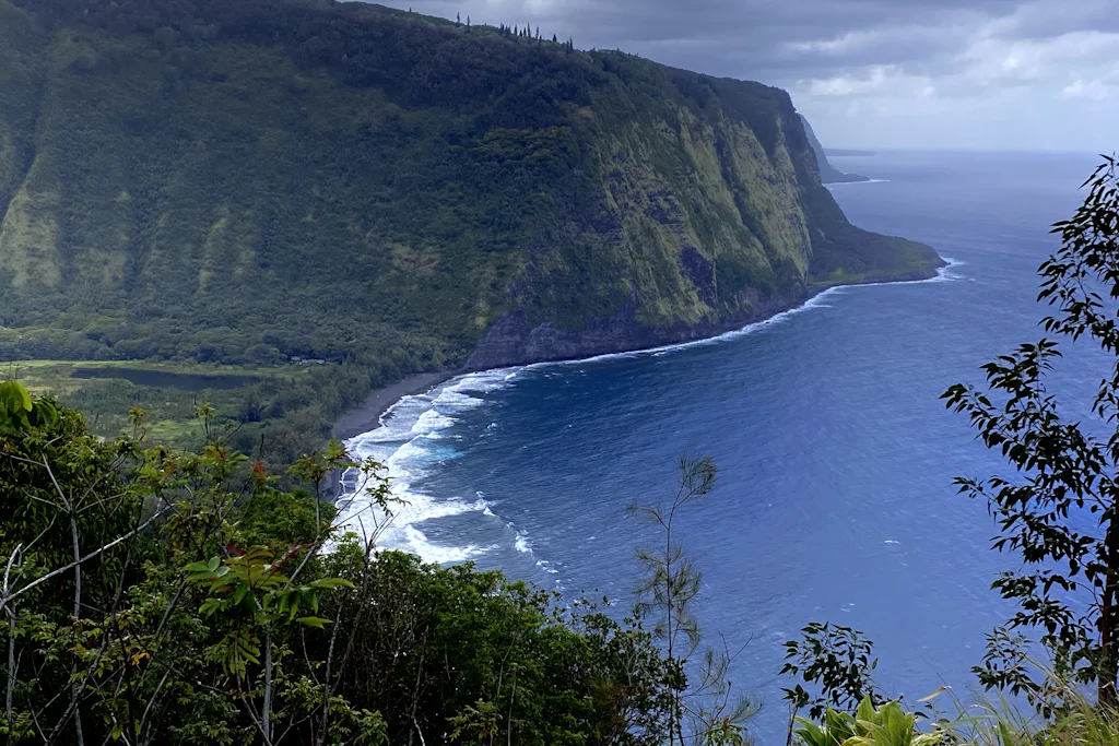
Start here, because for most visitors the lookout is the trip. The Waipio Valley (Waipiʻo) lookout is a paved platform at the rim, a 30-second walk from the parking lot, and it is free and open every day. From the railing the whole valley drops away: green cliff walls about 2,000 feet high, a mile wide floor of lush taro fields and river, and a mile long black sand beach where the surf meets the open ocean. The wind comes straight up the cliff face, and on a clear morning you can watch whales spout far below in winter; look north and the Hamakua coastline curves away in a line of green cliffs. It earns the word spectacular without trying.
Waipio Valley access, in plain terms
Two honest expectation setters before the drive. First, you cannot see Hiilawe Falls from the lookout - the valley's famous waterfall hides around a bend, so anyone promising falls from the rim is selling you a different view. Second, the lookout has restrooms and picnic tables, but the small parking area fills by midmorning on weekends, and there is no shade worth the name. Plan to visit early: better light, cooler air, and a spot in the lot. It's the kind of stop where the best things in Hawaii are free - a world famous view worth taking a half hour for.

Photo: Elijah Lychik on Unsplash
Quick facts: Cost: Free · Time: 30 minutes · Best: Early morning, before the lot fills · The move: Stand at the rim; the rest of this guide explains why.
02
Why Waipio Valley Road is closed (the 2026 status)
Here's the piece most older guides get wrong. Waipio Valley Road has been closed to nonresidents since February 2022, when Hawaii County issued an emergency rule over rockfall and slope instability on the access road. The road is genuinely treacherous - more on that below - and a string of geotechnical reviews found the conditions unsafe for public traffic. The closure has been renewed continuously ever since, and officials have indicated the fix could take two to three years.
From the lookout vs on the valley floor
From the lookoutOur pick
Free, open, 30-second walk
- The full sweep of the valley, cliffs, and bay
- The mile-long black sand beach, from above
- Whales in winter, far below
- No falls view - Hiilawe hides around the bend
- What 95% of visitors actually do
On the valley floor
Residents or shuttle tour only
- The black sand beach up close
- Taro fields and the river at eye level
- Hiilawe Falls when it's flowing
- Wild horses, if you're lucky
- Requires a booked tour - no DIY, no walking down
As of 2026, the rule still stands, and the county is actively studying the road: a geophysical survey closed it to all traffic for several days in February 2026 as part of a safety improvement project. What that means for you is simple. The lookout stays open; the descent, however, does not. Visitors cannot drive down, and walking down is off the table too - the road is closed, not just to cars. The only people legally driving the grade are Big Island residents in their own four wheel drive vehicles, plus the operators permitted to bring guests down. Everyone else stops at the rim. The valley floor below is also private property, lived in and farmed, so the closure is part road repair, part respect for the local families who work the land.
Quick facts: Status: Road closed to visitors since Feb 2022 · Why: Rockfall and slope instability · How long: Officials cite 2-3 years · The move: Plan around the lookout, not a drive to the bottom.
03
Getting down to the valley floor: residents, 4WD, and the shuttle tour
If you're set on reaching the floor, there are three ways, and two aren't available to you on vacation. The shuttle tour is the only option open to visitors. A permitted 4WD shuttle runs guests down to the valley floor with a guide; book ahead, because seats are limited and it is, at the moment, the one game in town. The horseback rides and mule drawn wagon tours that used to run are still suspended under the emergency rule, with no confirmed restart date, so don't plan a trip around them.
How to actually reach the valley floor
Book the shuttle tourVisitors
The Waipio Valley Shuttle is the one operating way for visitors to ride to the floor - a 4WD van with a guide. Book ahead; seats are limited and it's the only game in town.
Be a resident with 4WDLocals
Big Island residents can still drive the road in their own four-wheel-drive vehicle. That's not you on vacation - rental contracts forbid the road anyway.
Hike in from the back (Muliwai)Backpackers
The Muliwai Trail still runs from the valley toward Waimanu, but reaching its start means the closed road, so the legal, open route is a serious backcountry permit - not a casual walk down.
The other two routes are residents only or close to it. Big Island residents can still drive their own four wheel drive vehicle down, but that's not you in a rental - every rental contract on the island forbids this road for any vehicle, and they mean it. The road drops some 800 feet in barely half a mile, one of the steepest public roads in the country - the kind of slope where your brakes write a strongly worded letter. My honest verdict: pay for a tour only when you genuinely can't reach a place any other way - and the Waipio floor is now exactly that, the only door in rather than an upsell. If you just want the view, the free lookout gave you the headline; skip the descent with a clear conscience.
If the closure has you craving waterfalls and black sand you can actually reach, a Big Island sightseeing tour stitches several of those activities into one day - a fair backup when the floor is off the menu.
Quick facts: Visitors: Shuttle tour only, book ahead · Locals: Own 4WD, no rentals · Don't: Drive or walk down yourself · The move: Lookout for free; shuttle only if the floor is a must do.
04
The black sand beach and Hiilawe Falls
So what are you "missing" by not exploring the floor? Less than the rim makes it look, honestly. The valley floor holds a mile long black sand beach split by the river that drains the valley, framed by those 2,000-foot walls - a place of genuine beauty, and genuinely not worth risking a closed road for. The ocean here is rough and the currents are no joke, so even the residents and shuttle guests who reach it treat it as a look and wade beach, not a swimming one. You might also spot the valley's feral horses grazing the flats, descendants of animals left loose generations ago. The river bisecting the beach runs high after heavy rain, one more reason the valley keeps its own counsel.

Photo: Micah Alameda on Unsplash
The headline waterfall is Hiilawe Falls (Hiʻilawe), which plunges around 1,450 feet down the back wall, among the tallest in Hawaii. It's often a trickle or bone dry, because water upstream gets diverted, so the "phenomenal Hiilawe" shots come after rain. Down at the coast, other falls drop near the shoreline, including Kaluahine Falls, which turns up in film: the 1995 movie Waterworld used this stretch for its closing scenes. For the island's more reliable, accessible falls, our Big Island waterfalls roundup is the better planning tool, and most of them, unlike Hiilawe, run year round.
Waipio Valley by the numbers
Quick facts: Beach: Mile long black sand, rough surf · Falls: Hiilawe ~1,450 ft, often dry · Wildlife: Feral horses on the flats · The move: Admire it from the rim; the floor is a tour only bonus, not a swim spot.
05
Hiking near Waipio Valley: the Muliwai Trail to Waimanu
This is where guides quietly mislead people, so let's be clear. There is no casual hike down into Waipio Valley right now. The old move - walk the steep road to the floor and back - relies on the closed road, so it isn't legal or sensible while the rule stands, and any blog still describing that walk is out of date.
The real backcountry route is the Muliwai Trail, the punishing switchback path (locals call it the Z trail) that climbs out the far side of Waipio and runs roughly 6.5 miles to neighboring Waimanu Valley. It's a serious overnight for fit, prepared backpackers - thousands of feet of elevation, stream crossings, and full self sufficiency - and reaching its trailhead is complicated by the same closure. Heavy rain can swell those crossings to impassable, so the route effectively closes itself when the weather turns.
It also requires a free camping permit from the state, arranged in advance through the Division of Forestry and Wildlife in Hilo. In other words, the genuine Waipio hiking trails are for experienced backpackers only, and the casual day trails most visitors want aren't an option here; everyone else should treat the rim as the trailhead and call it a day. For a valley lookout where you can legally walk down to a black sand beach, that's Pololu Valley up the coast, not Waipio.
Quick facts: Down and back hike: Closed with the road · Real route: Muliwai Trail to Waimanu, backpackers only · Permit: Free, from state Forestry in Hilo · The move: Want to hike a valley? Do Pololu instead.
06
Valley of the Kings: the history of Waipio
Waipio is not just scenery, and this is the part worth slowing down for. For centuries it was one of the most important places in the islands - a political and religious center and a home of native Hawaiian royalty, which is why it carries the name the Valley of the Kings. Oral histories place anywhere from 4,000 to 10,000 people living on this floor before Western contact in 1778, farming the loi (taro patches) that the river and rain made some of the richest in Hawaii.
Why Waipio matters
- 1Before 1778
A seat of power
Oral histories place anywhere from 4,000 to 10,000 people in the valley before Western contact. It was a political and religious center and a home of Hawaiian royalty - the reason it carries the name Valley of the Kings.
- 21800s
Taro, then rice
Loi (taro patches) fed generations here; in the late 1800s immigrant families added rice paddies. The valley floor stayed farmed and lived-in.
- 3April 1, 1946
The tsunami
A massive tsunami swept the valley floor and the wider Hilo coast. Most families moved up and out for good, and the population never recovered.
- 4Today
Quiet and farmed
Roughly 50 people still live and grow taro in the valley. It is a living, private place - which is part of why access is handled with care, not just a road repair.
The valley's modern story turns on a single day. On April 1, 1946, a massive tsunami swept across the floor and the wider Hilo coast, and most families moved up and out for good; the population never recovered. Today roughly 50 people live and farm taro in the valley, and it remains private, working land rather than a public park. The loi that survived are still tended by hand in the traditional way, so the quiet you see from the rim is a working quiet. That history is why Waipio is treated as a sacred site, not a photo backdrop - don't hop the barricade or wander onto someone's loi. You're looking at a living cultural landscape, and the respectful move is simple: take it in from the rim, and leave it exactly as you found it.
Quick facts: Name: Valley of the Kings, a royal seat · Population then: 4,000-10,000 before 1778 · Turning point: The 1946 tsunami · Today: ~50 residents, private taro land.
07
How to get to Waipio Valley on the Big Island
The lookout sits at the very end of Highway 240, past the old sugar town of Honokaa - worth a stop to browse its storefronts - on the island's north coast. From Hilo it's about an hour: Highway 19 north along the Hamakua coast, then turn onto Highway 240 and run northwest about 9 miles to where the road simply ends. From Kona, budget two hours up through Waimea before you turn down toward the coast. Either way, the drive is half the reward - the Hamakua coast is a green, cliff lined run of waterfall pullouts, photo spots, and plantation towns.
Directions to the lookout
Tap to open Google Maps with turn-by-turn directions.
Driving to the Waipio Valley lookout
- 1From Hilo
About 1 hour
Take Highway 19 north along the Hamakua coast to Honokaa, then Highway 240 northwest for about 9 miles. The road dead-ends at the lookout parking lot.
- 2From Kona
About 2 hours
Highway 19 north through Waimea, then down to Honokaa and out Highway 240. Pair it with Waimea or the Hamakua coast to make the drive worth it.
- 3Go early
Beat the lot
The small lookout lot fills by mid-morning on weekends. Early light is also better for photos and cooler for the standing-around part.
- 4Don't drive down
Park and stop
Past the lot the road is closed to visitors, brutally steep, and off-limits to rental cars. The lookout is the trip - treat the barricade as the end of the line.
Because it's a long way to come for one viewpoint, build your travel day around it. Pair the lookout with Akaka Falls and the Hamakua coast on the way up from Hilo, or with cowboy country Waimea on the way from Kona - our Parker Ranch and Waimea guide covers that area. If you're basing nearby, the closest beds are the Kohala Coast resorts and small local Waimea inns; compare options in our where to stay on the Big Island guide. And if you're stitching together a north side day, the things to do in Hilo guide is the natural companion, since most people launch the drive from there.

Photo: Rohit Tandon on Unsplash
Quick facts: From Hilo: ~1 hour · From Kona: ~2 hours · Park: End of Hwy 240, lot fills by midmorning · The move: Make it a Hamakua coast day, not a special trip for one photo.
We set up beach picnics on Oahu, not the Big Island, so we have no stake in your north coast plans - which is why these tips are honest: come for the lookout, respect the closure, let the drive carry the day.
FAQ: Visiting Waipio Valley Big Island Hawaii
Is Waipio Valley the same as Pololu Valley?
No - they're two different valleys on the Big Island's north coast, and people mix them up. Both are green walled valleys with black sand beaches and free lookouts. The key difference in 2026: you can legally hike down into Pololu Valley, but not Waipio. To set foot on a valley floor, do Pololu.
Can you see Waipio Valley from a helicopter or boat?
Yes, and it's one of the better ways to see the valley floor now that the road is closed. Big Island helicopter tours, many from Hilo or Kona, fly over Waipio and the Hamakua coast, giving you the inside the valley angle the rim can't. It's not cheap, but it packs several Big Island experiences into one trip.
Can you swim at the Waipio Valley black sand beach?
Not safely, and most people can't reach it anyway. The beach has strong currents, rough shore break, and no lifeguards, so even residents and shuttle guests treat it as a wading and looking beach. With the road closed to visitors, the only way to stand on it is a permitted tour.
Are there wild horses in Waipio Valley?
Yes - a small herd of feral horses lives on the valley floor, descendants of animals turned loose generations ago. You may catch a glimpse of them grazing the taro flats from the lookout, or up close on a shuttle tour. They're not managed or tame, so keep your distance.
When will Waipio Valley reopen to visitors?
There's no confirmed reopening date. The emergency closure has been renewed continuously since February 2022, and county officials have indicated the road work could take two to three years. As of 2026 the lookout remains open and the floor remains tour or resident only, so check the latest county information before you go and plan your trip around the rim view.
Disclosure: Some links on this page are affiliate links. If you book or buy through them we may earn a small commission, at no extra cost to you. As an Amazon Associate, we earn from qualifying purchases.


